

Section A: (25 marks)
Answer all the questions in this section,
1. (a) Give two uses of diamond. (2 marks)
(b) Identify three problems facing diamond mining in South Africa. (3 marks)
2 (a) Apart from coniferous forests, name two other types of natural forests. (2 marks)
(b) State three characteristics of coniferous forests which favour their exploitation.
3 Use the map of East Africa below to answer question (a). (3 marks)
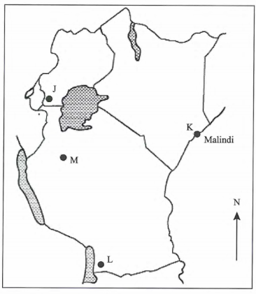
(a) Name the game reserves marked P, Q and R. (3 marks)
(b) State two factors which influence the distribution of wildlife in East Africa. (2 marks)
4 (a) Give two reasons why Geothermal power has not been fully exploited in Kenya. (2 marks)
(b) State three causes of the energy crisis in the world. (3 marks)
5 (a) Identify the two types of internal trade. (2 marks)
(b) Give three factors that limit trade among the member states of the common market for Eastern and Southern Africa (COMESA). (3 marks)
SECTION B: (75 marks)
Answer question 6 and any other two questions in this section.
6 Study the photograph below and use it to answer question (a)
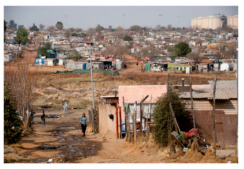
(i) Identify the type of photograph shown above. (1 mark)
(ii) Name the type of settlement shown on the photograph. (1 mark)
(iii) What time of the day was the photograph taken? (1 mark)
(iv) Draw a rectangle measuring 15 cm by 10 cm. On it, sketch and label five human features shown on the photograph.
(b) Explain four economic factors that influence settlement. (8 marks)
(c) Describe four negative effects of urbanization. (8 marks)
Explain three social factors that influence agriculture. (6 marks)
(i) Describe the cultivation of oil palm from land preparation to harvesting. (7 marks)
(ii) Give three uses of palm oil in Nigeria. (3 marks)
(c) Explain three reasons why horticultural farming is encouraged in Kenya. (6 marks)
(d) Give three factors which favours beef farming in the Nyika plateau. (3 marks)
8. (a) Explain four ways in which land is being rehabilitated in Kenya. (8 marks)
(b) (i) State two ways in which the salinity ofthe polders is reduced in The Netherlands. (2 marks)
(ii) Explain four ways in which the Zuyder Zee project benefits The Netherlands. (8 marks)
(c) You intend to carry out a field study on irrigation farming in Mwea Tebere Irrigation Scheme:
(i) Identify the two types of hypotheses you would develop for the study. (2 marks)
(ii) Name three crops, grown in the scheme that you are likely to identify. (3 marks)
(iii) Give two reasons why you need to sample the area of study. (2 marks)
9. (a) Define the term fishing. (2 marks)
(b) Explain two ways in which each of the following factors negatively affects fishing in Kenya.
(i) Agricultural activities. (4 marks)
(ii) Water weeds. (4 marks)
(c) Use the map of North-West Atlantic fishing ground to answer questions (c)(ii) and (iii).
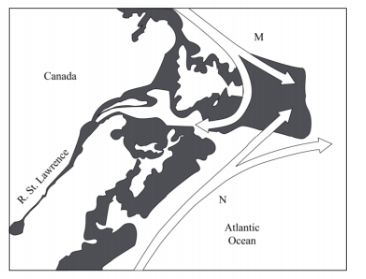
(i) Give three types of fish species caught in the North-West Atlantic fishing ground. (3 marks)
(ii) Name the Ocean currents marked M and N. (2 marks)
(iii) influence fishing. (4 marks)
(iv) Give three differences between fishing in Kenya and Japan. (6 marks)
10 (a) What is environmental management?
(i) Explain four negative effects of floods.(8 markes)
(ii) State two measures being taken to control lightning.(2 marks)
Explain the significance of conserving the environment (8 marks)
(d) Your Geography class carried out a field work on floods along a river.
(i) Name two types of field work they could have used.
(ii) Give three advantages of studying floods through field work. (3 marks) (2 marks)
Explain two ways in which the convergence of Ocean currents marked M and N (3 marks)