

KCSE Past Papers Geography 2013
4.2.1 Geography Paper 1 (312/1)
SECTION A
Answer ALL the questions in this section.
1. a) The diagram below represents the structure of the atmosphere. Use it to answer question (a).
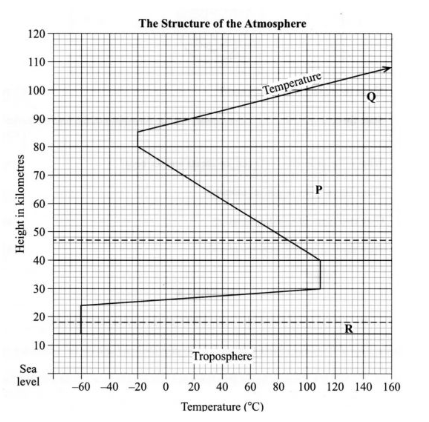
a) Name
(i) the parts marked P and Q. (2 marks)
(ii) the layer of discontinuity marked R. (1 mark)
b) State two characteristics of the weather conditions in the troposphere. (2 marks)
2. State five factors that influence mass wasting. (5 marks)
3. The diagram below shows a section of a river. Use it to answer the questions that follow.
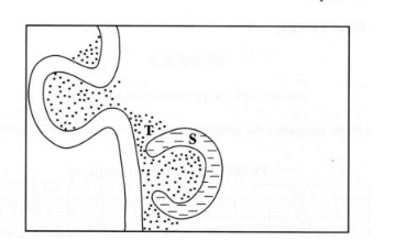
(a) Name the features marked S and T. (2 marks)
(b) State three conditions that are necessary for the formation of the feature marked S. (3 marks)
(a) What is the difference between ice sheets and ice berg? (2 marks)
(b) Name three types of glacial moraines. (3 marks)
(a) Give two types of soil degeneration. (2 marks)
(b) State three economic benefits of soils. (3 marks)
SECTION B
Answer question 6 and any other TWO questions from this section. Study the map of Karatina l:50,000 (sheet 121/3) provided and answer the following questions
(a) (i) What is the four figure grid reference of the Technical Institute at Mathira? (2 marks)
(ii) What is the bearing of Mount Kenya Campus at grid reference 932568 from the cattle dip at grid reference 990529? (2 marks)
(iii) Measure the distance of the railway line from the Level Crossing at grid square 8652 to the Southem edge of the map. Give your answer in kilometres. (2 marks)
(b) Draw a rectangle measuring 15 cm by lO.cm to represent the area enclosed by Eastings 90 and 100 and Northing 50 and 60. (1 mark)
b) On the rectangle mark and name the following:
(i) Kirinyaga District;
(ii) All Weather Road Bound Surface;
(iii) Forest;
(iv) Coffee factory.
(4 marks)
c) Describe the distribution of the natural vegetation in the area covered by the map. (6 marks)
d) Identify two social functions of Karatina town. (2 marks)
e) Citing evidence from the map, explain three factors that favour trading in the area covered by the map. (6 marks)
7 a) Name the first two planets of the solar system. (2 marks)
b) Explain the origin of the earth according to the Nebula Cloud Theory. (8 marks)
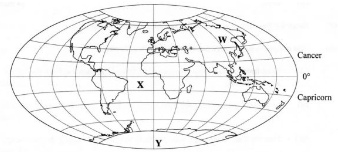
I the continent marked W; (1 mark)
II the ocean marked X; (1 mark)
IH the line of longitude marked Y. (1 mark)
(ii) Give two reasons why the earth has a spherical shape. (4 marks)
(iii) State four effects of the rotation of the earth on its axis. (4 marks)
c) Describe the structure of the earth’s crust.
8. a) What is volcanicity?
b) (i) Apart from a sill, name three other intrusive volcanic features. (3 marks)
(ii) Describe how the following features are formed:
c) Explain four negative effects of earthquakes.
9. a) What is vegetation?
I a sill; (3 marks)
H hot springs; (5 marks)
III a caldera. (4 marks)
b) Explain how the following factors influence the distribution of vegetation:
(i)Relief
(ii) soils.
c) Describe the characteristics of the savanna vegetation region. relief (2 marks)
d) You are planning to carry out a field study in a forest.
i. Give four reasons why it is important to seek permission from the school administration. (4 marks)
ii. List three sources of information you are likely to use before the actual field study. (3 marks)
iii .Identify four challenges you are likely to encounter during the field study. (4 marks)
10. (a) (i) Name two major deserts found in Africa. (2 marks)
The diagram below represents features resulting from wind erosion in a desert. Use it to answer question a(ii).
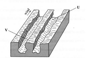
(ii) Name the features marked U and V. (2 marks)
(b) Describe the three processes through which wind transports its load. (6 marks)
(c) Using a well labelled diagram, describe how a barchan is formed. (7 marks)
(d) Explain four ways in which desert features are of significance to human activities. (8 marks)