
Process in which solid, liquid or gaseous materials are forced out of the interior of the earth into the earth’s crust or onto the earth’s surface. These materials are magma, lava, gases, dust, ash and cinder.
Causes of Vulcanicity
- Magma under high temperature and pressure moving through lines of weakness or faults.
- When tectonic plates move away from each other and boundaries give way to magma.
- Underground water coming into contact with hot materials hence changing into gaseous form.
There are 2 types of Vulcanicity:
Extrusive Vulcanicity (volcanic): in which materials intrude crustal rocks and don’t reach the earth’s surface. Magma is the molten material while it’s underground.
Intrusive Vulcanicity (plutonic): in which materials reach the earth’s surface.
Lava is the molten material after it reaches the surface.
There are two types of lava and magma, acidic and basic. Acidic lava is viscous and solidifies quickly and doesn’t spread far but accumulates around the vent. Basic lava is more fluid or less viscous and takes longer before cooling and spreads for great distances before doing so. Other materials emitted are gases, ashes, dust and cinder. The solid materials are called pyroclasts. Materials come out through a hole/vent (vent eruption) or crack/fissure (fissure eruption).
Features Resulting From Vulcanicity -Divided into intrusive and extrusive features or landforms.
Intrusive/Plutonic Features
Features formed by intrusive Vulcanicity when materials intrude the earth’s crust.
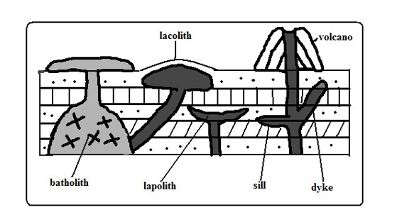
Sill
An igneous intrusion which lies along a bending plane of rock strata. -Formed when magma forces its way between rock layers then cools and solidifies.
It forms ridge like escarpments when exposed by erosion e.g. Fouta Djalon highland of Guinea and 3 sisters of S. Africa.
Dyke
A wall-like igneous intrusion which lies across the bedding plane of rock strata. -Formed when magma intrudes cracks or faults cutting across bedding planes of rocks then cools and solidifies.
Can be vertical or inclined.
When exposed it forms ridges e.g. Kaap Valley in Transvaal S. Africa and Jos Plateau in Nigeria.
Laccolith
A mushroom-shaped igneous intrusion lying between bending planes of a country rock.
Formed when viscous magma pushes its way through a vent and accumulates around the vent before reaching the earth’s surface pushing the overlying rock into a dome shape.
Its so high that land is turned into mountains e.g. El Koub Hill in Algeria, Henry Mountains in Utah U.S.A and Fonjay Massif in Madagascar.
Batholiths
Largest igneous intrusion formed underground formed when very hot magma intrudes bedding planes of rocks and replaces or metamorphoses it e.g. Chaila Massif in Gabon, Ikhonga-Murwe in Kakamega and the largest is in British Columbia.
Lopolith
a large saucer shaped igneous intrusion formed when viscous magma intrudes into bedding planes of a country rock. They form shallow depressions on the earths surface of the earth e.g. Bushveld complex in S. Africa and Duluth Gabbro mass in U.S.A.
Phacolith
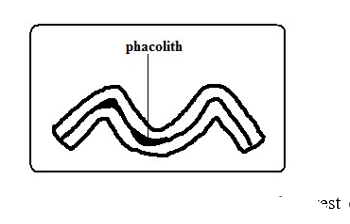
A lens shaped igneous intrusion which forms in the crest or trough of an anticline e.g. Corndon Hill in England.
Extrusive/Volcanic Features
Formed when magma reaches the earth’s surface through vents or fissures.
Volcanoes
A volcano is a cone shaped hill formed when volcanic materials flow out and accumulate around a vent. Volcanoes are classified into three groups:
- Active volcano- which is known to have erupted in recent times e.g. OL donyo Lengai in Tanzania and Mt. Cameroon, and Mauna Loa in Hawaii.
- Dormant volcano-not known to have erupted in the recent past but show signs of volcanic activity such as presence of hot springs, geysers and fumaroles e.g. Mt. Kilimanjaro, Longonot and Menengai.
- Extinct volcano-which has not shown signs of possible future eruptions e.g. Mountains Kenya and Elgon.
Types of Volcanoes
Acidic Lava Domes
A steep dome shaped volcanic hill made of acidic lava.
Viscous lava flows out through a vent.
- It accumulates around the vent because it’s viscous.
- Eruptions occur later and lava flows out covering the layers below.
- A steep sided dome shaped mound of volcano is formed e.g. Itasy Massif of Madagascar, Mt. Kenya and Kilimanjaro.
Characteristics
-
- Its dome-shaped
- Has steep slopes
- Made of acidic lava
- Has lava layers
- Has steep slopes
- Has a narrow base
Basic Lava Domes/Shield Volcanoes
A low lying volcanic hill made of basic lava.
- Basic magma flows out to the surface through a vent.
- The lava flows far before solidifying because its fluid.
- Eruptions occur later and lava spreads over the old lava.
- A shield shaped mound of volcano is formed e.g. Canary Islands, Cape Verde and Sao Tome which are volcanic Islands in the Indian Ocean.
Characteristics
- Dome/shield shaped
- Has gentle slopes
- Made of basic lava
- Has lava layers
- Has a broad base
Ash and Cinder Cones
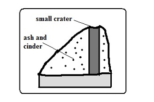
A volcano built from ash and cinder or small fragments of lava.
- Violent vent eruption occurs.
- Ash and pyroclasts are emitted and thrown high.
- Some materials fall and settle around the vent forming a hill.
- Light materials are blown by wind to the leeward side e.g. Chyulu Hills, Teleki and Likaiyu near L. Turkana.
Characteristics
- Made of pyroclasts
- Asymmetrical about the axis
- Cone shaped
- Has smooth slopes
Has steep windward slope and gentle leeward slope
Composite /Complex/Stratified Volcanoes
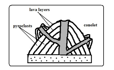
A volcano made of alternating layers of lava and pyroclasts and conelets.
- The first eruption throws out pyroclasts.
- Then viscous lava flows out and solidifies on them.
- Eruption occurs later blowing the rocks sealing the vent.
- The pieces of rock settle on earlier solidified lava.
- Another mass of lava flows out and spreads over pyroclasts and solidifies.
- The process is repeated causing the volcano to build upwards
- The conelets are formed when magma is unable to overcome the plug and finds its way through weak lines at the sides and then pyroclasts and lava accumulate around the side vent e.g. Mountains Kenya, Longonot, Elgon and Kilimanjaro.
Characteristics
- Cone shaped
- Stratified (made of alternating layers of lava and pyroclasts.
- It has conelets (parasitic cones).
- It has steep slopes.
- Made of acidic lava
Plug Dome/volcano/Spine
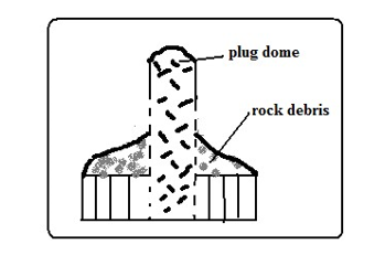
A column of very viscous lava which sticks above the ground.
- A column of very viscous magma flows out of the ground.
- It cools and hardens rapidly as it rises vertically.
- Pieces of rock break from the plug and accumulate on the sides e.g. Mont Pelee in West Indies, Hyrax and Fischer’s Tower at Hells gate in Naivasha and Devils Tower in U.S.A.
Characteristics
- Made of very viscous lava.
- It is dome shaped like a mushroom germinating out of the ground. (c) Has debris on its sides.
- Has very steep sides
- Cylindrical in shape
- Disintegrates fast due to rocks undergoing rapid cooling.
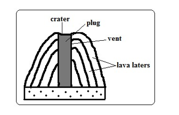
Volcanic Plug
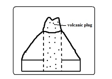
Stump of rock formed when magma which solidified inside a vent (plug) is exposed by denudation.
- A volcano is first formed.
- Lava on the sides of the volcano is eroded fast due to cooling fast.
- The lava in the vent which is hard due to slow cooling is exposed forming a stump of rock e.g. Peaks of Mt. Kenya, Rangwa Hill and Tororo Rock.
Characteristics
- It resembles a stump of a tree.
- Its dome shaped.
- Very steep at the top and less steep at the bottom
- Made of hard/resistant rock
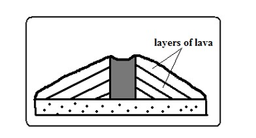
Lava Plains and Plateaus
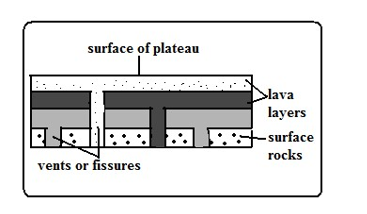
Lava plain: fairly level lowland below 500m above sea level covered by thin lava layers.
Lava plateau: fairly level highland/upland above 500m above sea level covered by thick layers.
Formed by fissure eruption.
- Magma of low viscosity comes out of the ground through a fissure.
- It flows for a long distance before cooling and solidifying filling depressions and valleys forming a plain.
- Eruption occurs later and lava flows out through lines of weakness on crustal rock and solidified lava.
- The new lava spreads on top of the old lava forming a new layer.
- The process is repeated and a plateau is formed e.g. Mwea, Nandi and Laikipia Plains and Yatta and Uasin Gishu Plateaus.
Craters
A funnel shaped depression found on top of a volcano.
Modes of Formation Cooling and Contraction of Magma
- Eruption occurs and a volcano is formed.
- Magma in the vent cools and contracts.
- It withdraws into the vent leaving a depression at the vents mouth e.g. Ngorongoro and Menengai craters.
- Rain water or water from melting snow may collect into craters to form crater lakes e.g. L. Paradise on Mt. Marsabit, L. Magadi on Ngorongoro Crater and L. Chala on Kenyan Tanzanian border.
Explosion
- Gases underground expand due to heat from magma.
- They force their way out through a weak line in the crustal rocks.
- An explosion occurs leaving a hole in the ground called a ring craterg. Ghama and Dobot craters in Tanzania and Hora craters inEthiopia.
- Water from underground or rivers may accumulate into ring craters to form lakes called maarsg. Lakes Katwe and Nyungu in Uganda.
Falling of a Meteorite
- A meteorite falls on the earth’s surface.
- It sinks into the rocks leaving a depression.
- Water may collect into the depression forming a lake e.g. L. Bosumtwi in Ghana.
Calderas/Basal Wreck
A very large basin-shaped depression on the summit of a volcano.
Modes of Formation
Violent Explosion
- Gases and water heated by magma expand.
- They force their way through a vent.
- The rocks at the top of the volcano are blown off forming a large depression e.g. Nyirarongo Caldera in DRC and Sabiro Caldera in Uganda.
Block Subsidence/Cauldron
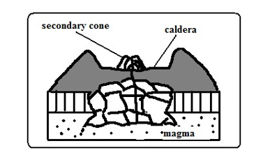
- Eruption occurs to form a volcano.
- An empty space (cauldron) is left in the magma reservoir in the mantle.
- The rocks forming the middle of volcano are pulled inwards by gravity.
- The middle of the volcano collapses forming a large depression at the top e.g. Menengai Caldera near Nakuru and Ngorongoro caldera which is the largest in E. Africa and 6th largest in the world.
- Water from rain or underground may fill calderas to form lakes e.g. L. Magadi in the Ngorongoro caldera and L. Ngozi in Tanzania.
Outward Collapsing
- Ash and pyroclasts volcano grows high.
- Materials on top exert pressure on those below.
- Materials at the base begin to spread outwards.
- The top of volcano collapses inwards forming a collapse caldera e.g. Napak Caldera in Uganda.
A vent in a volcano which emits gases.
Fumaroles
The gases come from chemical reactions in crustal rocks when heated by magma or when minerals in rocks come into contact with hot air and steam underground.
They are of two types:
Mofette: fumarole which emits carbon dioxide.
Solfatara: fumarole which emits gases with sulphurous compounds.
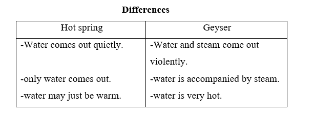
Hot Springs and Geysers
Hot spring is a place where hot water is emitted from the ground quietly e.g. at the shores of Lakes Magadi and Bogoria.
A geyser is a jet of water and steam which are violently ejected from the ground e.g. at Olkaria and western shores of L. Bogoria.
How They Are Formed
- Percolating water is heated by hot rocks or magma.
- Some collect into chambers called sumps where it develops pressure causing it to be superheated super heated.
- The pressure forces the steam outwards towards the earths surface through holes and cracks in rocks.
- The steam comes out of the ground which reduces pressure in sumps causing the water to expand/boil and come to the surface.
- The steam comes out with a whistling sound accompanied by water forming a geyser.
- The escaping steam heats ground water in surrounding rock.
- The heated water may find its way to the surface where it quietly comes out of the ground forming a hot spring.
Pools of Boiling Water
Small area of still water which appears to be boiling.
- Actual heating of pool water by gases and steam causing the water to boil.
- Gases and steam coming out below the pool of water causing the pool to bubble and appear as if it’s boiling.
World Distribution of Volcanoes (
- Regions of faulting e.g. the Great Rift Valley of E. Africa.
- Mid-Atlantic ocean ridge.
- The western coast of America.
- Zones of recent mountain building e.g. fold mountains of S.E Asia.
Significance of Vulcanicity Positive
- Volcanic rocks weather to form fertile agriculturally productive soils e.g. basalt.
- Geysers are sources of geothermal electricity e.g. at Olkaria.
- Hot springs water is pumped into houses for heating during winter e.g. Iceland.
- Volcanic features are a tourist attraction e.g. hot springs, geysers and snow capped Mt. Kenya.
- Igneous rocks e.g. phonolites are crushed to make ballast for building roads, bridges, etc.
- Crater lakes are a source of fish e.g. L. Katwe in Uganda, sources of minerals e.g. L. Magadi and sources of water for domestic use.
- Volcanic mountains are catchment areas, sources of rivers and habitats for wildlife.
- Pumice a volcanic rock is used as a scrubbing stone.
- Vulcanicity is useful for production of gases e.g. carbon dioxide used in soft drinks manufacture.
Negative
- Volcanic eruptions cause of life and destruction of property e.g. sulphur dioxide, ash, cinder and lava may bury houses and farm land.
- Volcanic mountains are barrier to transport and communication.
- Volcanic mountains on the path of rain winds cause leeward slopes to receive little rainfall by preventing rain bearing winds from reaching there.
- Volcanic eruptions cause environmental pollution from dust, ash and sulphur dioxide.
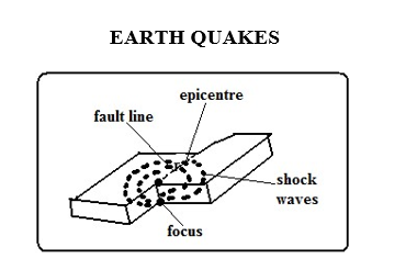
Sudden and rapid movement of the earths crust.
areas prone to them are called seismic zones and those not prone are called aseismic zones.
It’s caused by shock waves.
There are 3 types of earthquake waves namely:
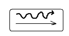
- Primary waves-which travel fastest and cause the rock particles to vibrate in a push and pull manner and can pass through gases, liquids and solids.
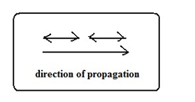
2. Secondary waves-which cause rock particles to vibrate at right angles to the direction of wave movement.
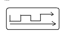
3. Surface longitudinal waves-which cause surface rocks to shake sometimes causing buildings to collapse.
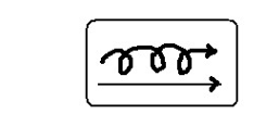
Rayleigh waves-Which cause surface rocks to move in elliptical orbits.
Love waves-which cause rock particles to move in a horizontal manner at right angle to the direction of wave
Earth quake originates from a point known as seismic focus/origin. The part of the earth vertically above the seismic focus and where the shock waves are first experienced is called epicentre.
Causes of Earthquakes
Natural Causes
- Tectonic movements e.g. movement of tectonic plates. They cause tectonic earthquakes.
- Vulcanicity when magma movement displaces rocks suddenly shaking and shuttering them.
- Gravitative force when crustal rocks collapse into cauldron due to gravity.
- Energy release in the mantle when radioactivity takes place in mantle releasing explosive energy which sends shock waves outwards.
- Isostatic adjustment when the continental masses rise to restore the upset state of balance between sial and sima layers.
Human Causes
- Exploding nuclear bombs underground which causes shock waves which spread outwards and are felt in the neighbourhood.
- When a train rolls on its rails causing the ground to vibrate.
- Explosion of explosives used in mining and quarrying which cause vibrations to be felt in the neighbourhood.
- When large reservoirs are constructed and the heavy weight of water reactivate dormant faults causing tremors.
Measurement of Earthquakes
Seismograph is a pendulum based instrument used to measure earthquakes. It records seismic impulses on a graph-like record called seismogram mounted on it.
Earthquakes are measured by their intensity and magnitude.
Intensity
Measure of how strong/hard the quake shakes the ground.
It’s seen from the effects the earthquake has on people, buildings and other structures.
It’s measured on the Mercalli Scale which uses a scale running from Roman ixiii e.g.
- I- description -imperceptible
- V-rather strong-sleepers are awakened and there is swinging of objects.
- VIII-destructive-gaping cracks in walls some brought down.
- XII- major catastrophe-every building destroyed.
Magnitude
Measure of amount of energy given off by an earthquake.
It’s measured on Ritcher Scale which ranges from 0-8.9.
Intensity values depend on how far a place is from epicentre. The higher the scale the more severe the earthquake is.
- Intensity I-magnitude 2
- Intensity VIII-magnitude 6
- Intensity XII-magnitude 8.5.
World Distribution of Earthquakes
- Within the zones of major faulting e.g. Rift Valley.
- In areas of Vulcanicity e.g. Oldonyo Lengai in Tanzania.
- Along boundaries of tectonic plates e.g. Japan, Philippines, East Indies and west coast of north and South America.
Effects of Earthquakes
- Can cause loss of life and property when buildings collapse burying people.
- Disrupt transport and communication by vertically and laterally displacing land which disconnects pipelines, electricity lines, roads and railways.
- Causes landslides which also cause loss of life and property and disrupts communication.
- Causes raising and lowering of the sea floor and the coastal regions.
- Cause huge sea waves called Tsunami which may flood the neighbouring coastal areas.
- Trigger folding, Vulcanicity and fires.
- Give off a lot of explosive energy more than an atomic bomb.
- Cause fear and panic.
- Hinder settlement as it is restricted to aseismic areas.
- Cause violent motions of the earth’s surface.