
Faulting is the cracking/fracturing of the brittle crustal rocks due to tectonic forces.
Faults are fractures or cracks that develop in the crust.
- When tensional forces cause crustal rocks to stretch and fracture at the region of maximum tension.
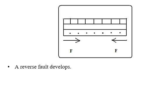
- When compressional causes squeezing of crustal rocks to fracture at the areas where they are intensely squeezed.
- When vertical movements exert pressure on rocks leading to fracturing.
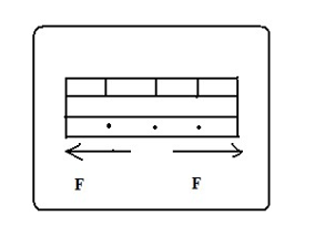
- When shear forces cause crustal rocks to tear.
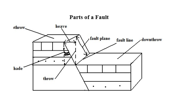
- Upthrow-part of the land displaced upwards.
- Down-throw-part of the land displaced downwards.
- Throw-vertical displacement.
- Heave-horizontal displacement
- Hade-inclination of fault to vertical plane
- Fault line-fault path
- Fault plane-separation of land created by the fault
Types of Faults
Normal Faults
Type formed by tensional forces in which one block slides downwards in relation to the other.
Rocks are subjected to tensional forces
- A normal fault develops
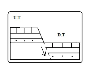
- One block slides downwards.
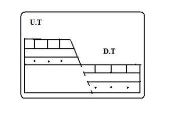

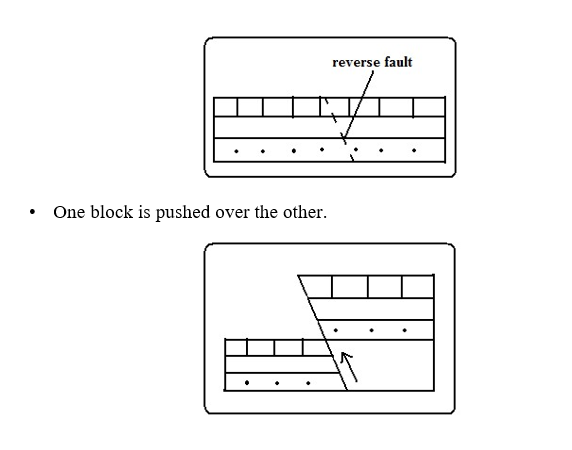
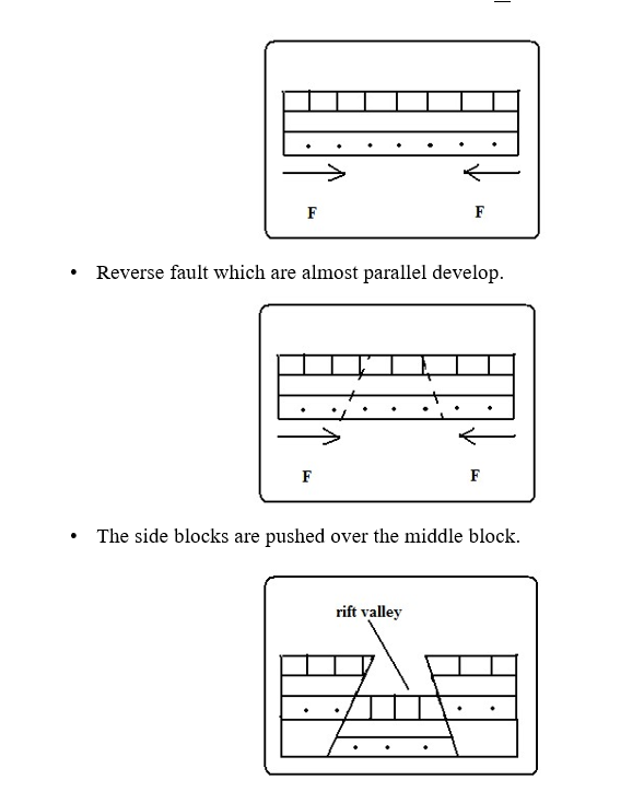
Reverse Fault
Type formed by compressional forces in which one block of land is pushed upwards in relation to the other.
- Rocks are subjected to compressional forces.
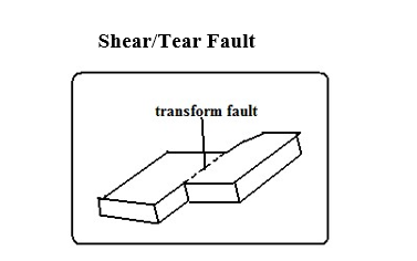
Type formed by shear forces in which adjacent blocks of land slide past one another. If a shear fault occurs between continents it’s called a Transform fault e.g. San Andrean fault of California and great glen fault of Scotland.
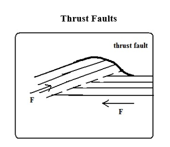
Type formed when very strong compressional forces cause almost horizontal faults to develop and one block of land is pushed over the other.
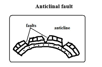
Type formed when anticlines are compressed further and cracks form on the crest.
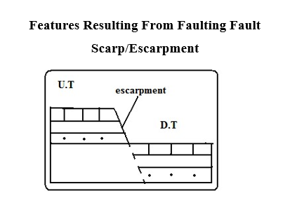
Steep line of slopes formed by vertical movement of earth along a fault e.g.
Mau, Nguruman, Nyandarua and Nandi.
Are exposed parts of a fault plane.
It may be formed due to normal faulting or reverse faulting when overhanging blocks are eroded.
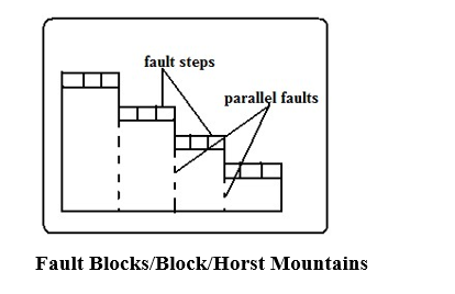
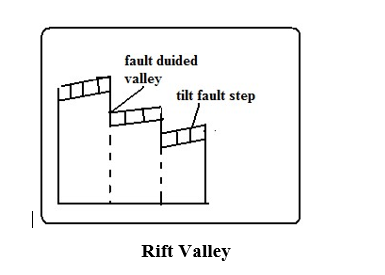
Fault Steps
Land resembling the staircase or steps of a house with a series of fault scarps at different levels.
- Parallel vertical faults develop.
- Land between the faults is unequally displaced downwards.
- A series of fault scarps at different levels is formed. -E.g. Keiyo escarpment and at Kijabe.
Blocks of land raised above the surrounding land.
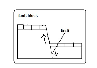
- Where tectonic forces cause faulting and land on one side of the fault get raised or sink along the fault planes.
Examples of fault blocks are Aberdare/Nyandarua ranges, Mau escarpment and Nandi Hills.
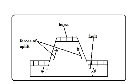
- Where Blocks of land bordered by normal faults which are almost parallel to each other sink leaving the middle block standing. Examples of horsts are Ruwenzori of W. Uganda and Usambara and Pare mountains of Tanzania.
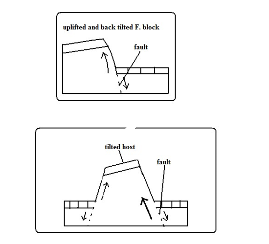
Tilt Blocks -Fault blocks which are inclined on one side.
- Occurs when the fault block, horst or fault steps have greater uplift on one side and as a result they are not flat at the top but tilted. The resultant features are tilted fault blocks, tilted horst and tilt fault steps which form ridges and fault guided valleys.
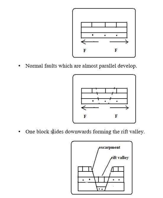
Along narrow trough with steep escarpments on both sides.
Theories of Formation
Tensional Theory
Rocks are subjected to tensional forces.
Compressional Theory
Rocks are subjected to compressional forces.
- Overhanging blocks are worn out by denudation to form escarpments
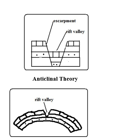
Suggests the rift valley was formed by Anticlinal arching.
- Upward forces pushed sedimentary rock strata upwards.
- The rock layers bent into a big arch.
- A gaping/huge crack developed at the crest of the arch due to tension forming the rift valley.
The Great Rift Valley/The Great E.A Rift Valley
The world’s biggest rift valley.
It starts in Syria and ends in Mozambique.
It’s divided into 4 parts.
- Ethiopian Rift system-starts from Afar in Ethiopia to the Kenyan border around L. Stephanie.
- Gregory Rift system-Starts from the northern border of Kenya with Ethiopia to Tanzania. It has a small N.E-S.W branches:
- Kano Rift valley in Kenya
- Eyasi Rift Valley in Tanzania
- Western Rift valley-Starts at Sudan border to south of L. Rukwa. Features which are here are Ruwenzori Mountain and Lakes Albert, Edward, Kivu, Tanganyika and Rukwa.
- Malawi Rift valley-a continuation of Gregory Rift system to Zambezi River in Mozambique. It has a small N.E-S.W branch called Luangwa valley.
The Gregory Rift Valley
Named after a geologist called Gregory J.W who carried out extensive studies in this area.
It’s where the Rift Valley features are more pronounced.
Features associated with it
- Fault blocks–Aberdare range, Mau, Nandi and Cherangani hills.
- Step faults-Kijabe and Tambach
- Tilt blocks-Aberdare range uplifted and tilted eastwards and Mau escarpment uplifted and tilted westwards.
- Lava flows and volcanic cones e.g. Menengai and Ngorongoro crater.
- Rift Valley lakes formed when unequal sinking created faults which were later filled with water. The lakes are deep and elongated. Examples are Lakes Naivasha, Nakuru, Elementaita, Baringo, Bogoria, Ol Bolossat and Turkana. Most of the lakes are salty with exception of L. Naivasha which has fresh water.
Why Most Rift Valley Lakes Are Salty
- Lack of outlets to drain away salts contained in them.
- Lack of enough water to dilute salinity due to little rainfall and lack of rivers flowing in them.
- High rates of evaporation causing increased accumulation of salts.
- Lake’s water being in contact with rocks with mineral salts which it directly dissolves.
- Washing into the lake of mineral rich soils by surface runoff.
Why L. Naivasha Has Fresh Water
- It has underground drainage to the Indian Ocean.
- There is inflow of fresh water from rivers and rain.
- The latest volcanic eruption covered the bed rock with lava.
Major Faulted Areas of the World
- The Great Rift Valley from Syria to Mozambique.
- Northern England and the Great Glen Fault of Scotland.
- The Central Massif of Europe.
- The middle Rhine Rift Valley region.
Significance of Faulting
To Human Activities
- Rift valley lakes are important for fishing, irrigation and domestic use.
- The Rift Valley and associated features are a tourist attraction which earns foreign exchange.
- Hot springs and geysers formed during faulting can be harnessed for geothermal power.
- Block Mountains are water catchment areas and sources of rivers due to the heavy rainfall they receive on the windward side.
- Faulting results in the exposure of minerals such as diatomite in Gilgil and Fluorspar in Kerio Valley.
- Fault scarps may expose underground water resulting in the formation of scarp springs.
- Unequal subsidence caused by faulting may cause formation of depressions which may form lakes which useful for fishing, transport and mining e.g. L. Naivasha.
Negative
- Faulting disrupts transport and communication by disjointing land.
- Faulting may lead to loss of life and property by causing land to sink.
- Faulting may cause a river to disappear or change its course and flow along the fault line.
- Steep scarp slopes formed by faulting are prone to soil erosion.
- Faulting has given rise to semi-desert conditions in some areas when Block Mountains on the path of rain winds cause leeward sides to receive little rainfall.