
An ocean is a large and extensive body of saline water occupying a basin between continents while a sea is a large body of saline water on the margins of continents.
Nature of Ocean Water
- Ocean water is salty
- Due to abundant sodium chloride which rivers dissolved from land, from rocks that the water is in contact with and volcanic materials on the ocean floor?
- Ocean water has high salinity in areas where there is addition of little water and high rate of evaporation leading to high salt concentration e.g. Dead Sea and lower where there is low temperatures and addition of fresh water from rivers, rain or snow melts e.g. Baltic Sea.
- Surface water is warmer than that at the bottom except in Polar Regions where a thin layer of cold water may overlie warmer water.
- Ocean water is a habitat for living organisms Planktons are plants and animals occupying ocean surface.
Phytoplankton are ocean plants e.g. algae.
Zooplankton are ocean animals e.g. lobsters, jelly fish, crabs, etc.
Types
- Nektons are all forms of fish.
- Benthos are ocean creatures which live only at the bottom of margins of continents where sunlight reaches Sea floor e.g. snails, starfish and sea anemones.
Ocean water is polluted e.g. by industrial effluents, pesticides and herbicides carried by rivers and runoff to the sea.
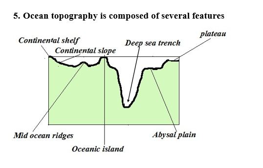
- Continental shelf- Relatively flat part of the continent covered by ocean water.
- Continental slope- Steeply dipping surface between continental shelf and the ocean basin proper.
- Abbysal plain- Almost level area of the ocean where sediments are deposited.
- Mid ocean ridges- Range of hills which are submerged formed by volcanic and seismic activities.
- Sea Islands– pieces of land surrounded by water.
- Continental islands– Ones rising from continental shelf.
- Oceanic islands–Ones which rise from the sea floor e.g. Canary and Cape Verde.
- Coral islands-Ones made of coral.
Deep sea trenches – narrow steep sided submarine valleys on the ocean floor.
Guyots– submerged atolls forming an under water mountain.
Sea mount– a volcano which doesn‟t rise above the sea floor. A portion of ocean water moves There are two types of movements namely:
Vertical Movements – Movement of ocean water from surface to bottom and vice versa.
How they occur
- Cold polar water sinking before moving horizontally towards equator.
- Ocean currents converge
- When ocean water sinks at lower depths after ocean currents converge.
- When ocean water rises to the surface in a process called upwelling.
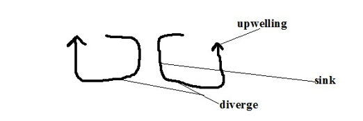
Significance of vertical movements
- Carries nutrients for sea animals by upwelling.
- Oxygenation of water vital for fish survival.
Horizontal Movements
It occurs in the following ways:
- Ocean Currents
An ocean current is a large mass of surface ocean water which is moving in a particular direction e.g.
- Mozambique- warm
- Canaries -cold o Benguela-cold
- N. Atlantic drift-warm
- Gulf stream drift-warm
Factors that influencing formation of ocean currents
- Wind by blowing over water causing a mass of surface ocean water to move in its direction forming drift currents.
- Rotation of the earth by causing deflection of ocean currents.
- Shape of land mass by influencing current direction and causing it to flow following the coastal outline.
- Differences in temperature by causing cold polar water which is dense due to low temp moves towards the equator passing on the ocean floor and warm water of the tropics to move towards the poles passing on the surface.
Tides
- Periodic rise and fall in the level of ocean and other large water bodies.
- Occurs when the moon and to some e the sun exert gravitational pull on the water bodies on the earth.
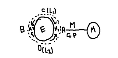
Moons gravitational pull is exerted on the earth causing the water on that side A to bulge resulting in high tide 1
Some water flows from sides C and D to side B to occupy space created by the moons pull resulting in high tide 2 and low tides 1 and 2 at C and D.
Rotation of the Earth
- It brings any longitude under the influence of 2 high and 2low tides in a lunar day.
- Similar tides occur at an interval of 12hrs 26 minutes.
- A lunar day is time taken by the earth to complete one rotation with respect to the moon (24 hrs 52 min)
- Lunar month is time taken by the moon to complete one revolution around the earth (27.3 days)
- The moon is always ahead of the earth by 52 minutes due to its revolution e.g. if Nairobi is opposite the moon at 6pm the following day the high tide will be at 6.52pm.
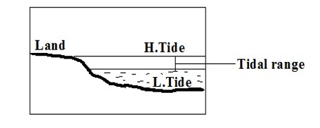
Tidal range is the difference between the highest level reached by high tide and lowest level reached by low tide.
Types of tides
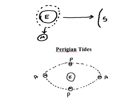
- Caused by relative positions of the moon and the sun from the earth.
- Sometimes the moon and the earth are nearer or farther from each other due to their elliptical orbits.
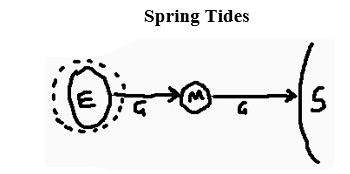
- In which the highest and lowest tides occur.
- Occurs when the sun, moon and the earth are in a line (syzygy position) and pulling in the same plane causing pulling force to be greatest.
Neap Tides
- In which high tide is lower than normal and low tide is higher than normal.
- Occurs when the sun, moon and earth form a right angle and pulling water to themselves.
- In which tidal range is 20% higher than normal.
- Occur when the moon is nearest to the earth (perigee position) causing pulling force to be greatest.
Apogean Tides – In which tidal range is lower than normal.
- Occur when moon is farthest from the earth (apogee position) causing pulling force to be weakest.
Diurnal Tides
- 1H1L in a lunar day
Semi Diurnal Tides – 2H2L in a lunar day which may rise or drop at the same level.
- Occur in most of Pacific Ocean.
Mixed Tides
- 2H2L in a lunar day where one pair may fluctuate in level while the other remains constant.
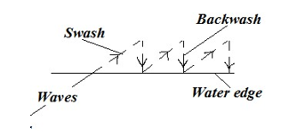
Waves – A wave is a moving ridge of water on the sea.
- It‟s formed when wind blows over an open water body causing oscillation of water particles.

Crest – the top of a wave.
Trough – the bottom of a wave.
Wavelength – horizontal distance between two successive crests.
Height – difference in height between crest and trough. o When a wave reaches the shore, the water particles below the surface start touching the ocean floor causing it to break.
- There is forward movement of water to the beach which is called swash/send.
- There is backward movement of water to the sea due to gravity called
- The rest flows at the bottom back into the sea in a water current called undertow.
Types of waves
1. Constructive Waves
- Waves in which swash is stronger than backwash resulting in deposition.
2. Destructive Waves
- Waves in which swash is weaker than backwash resulting in erosion.
Wave Erosion
Processes of Wave Erosion
1. Abrasion
- Scratching of ocean floor by materials carried by the back wash.
2. Corrasion
- Hurling of pebbles and rock fragments against the rocks causing some particles to break off.
3. Attrition
- Rock fragments dragged up and down by the swash and backwash hitting against each other becoming smaller in size. It provides tools for abrasion and corrosion.
4. Hydraulic Action
- Removal of materials from the coast by action of the force of moving water.
Direct wave force
- Large amounts of wave water crush against a rock face weakening and eventually breaking of the rock.
Compressed air action
- Waves crush against a rock.
- The force of water pushes air into cracks compressing it and exerting pressure causing them to widen.
- Wave retreats causing trapped air to expand resulting in sudden pressure release causing cracks to expand further.
- The process is repeated several times causing the rocks to shatter.
Solution
- Some soluble minerals in rocks dissolve directly in water and are carried away in solution leaving cavities in rocks.
Corrosion
- Some minerals such as limestone reacting with sea water which has dissolved carbonic acid.
Factors influencing wave erosion
- Waves must have strong backwash and a weak swash
- Slope –The coast that slopes steeply into the sea favours erosion.
- Load-large amount provides more abrasive tools. Angular shaped load is more effective in abrasion.
Amount of water in a wave – the larger the amount the greater the hydraulic force.
Features Resulting From Wave Erosion
- Cliff and Wave Cut Platform Cliff – A steep rock face which borders the sea.
Wave Cut Platform – A fairly flat part of the shore formed when a cliff retreats inland. o Breaking waves erode rock surface of a steep coast cutting a notch.
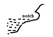
- Erosion continues causing the base of the rock to be undercut resulting into an overhanging rock.
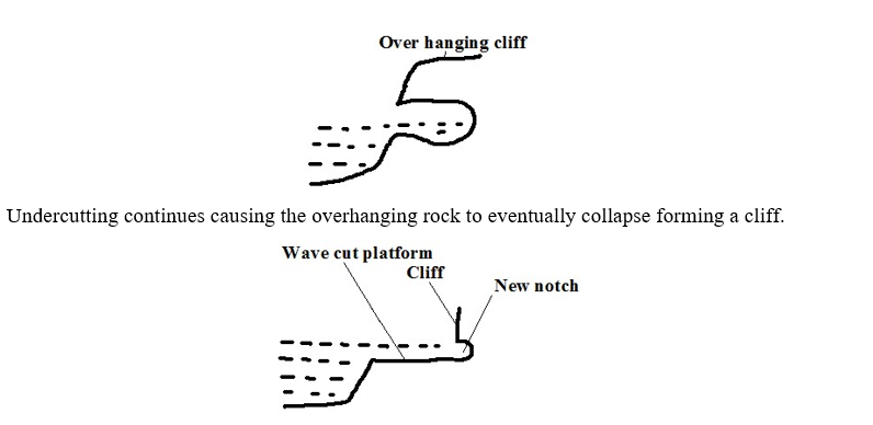
- The process is repeated and a fairly flat part of the shore is formed between the new and the former cliff.
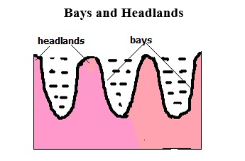
Bay – Piece of sea water jutting into the land or a curved inlet of sea.
Headland – a piece of land jutting into the sea.
- At first there is a coast with hard and soft rocks.
- Soft rocks are eroded more by wave action to form sea inlets called bays.
- Resistant rocks called headlands are left sticking into the sea. A big bay is called a gulf.
Caves, Blow Hole and Geos
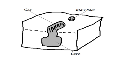
Cave – Natural cylindrical tunnel like chamber extending into the cliff or into the side of a headland.
- A small hollow form on a weak area of the cliff after limestone is acted upon by carbonation.
- Corrosion and direct dissolving act on the hollow extending it into the cliff forming a cave.
Blow Hole/ Gloup – Vertical hole formed on the side of cliff bordering the land.
- Formed when a cave reaches the surface some distance inland as a vertical pit.
It’s called a blow hole because when the waves break water is forced out of the hole.
Geos – Narrow sea inlet formed when the roof of a cave between the blow hole and the sea collapses.
Natural Arch, stack and stump
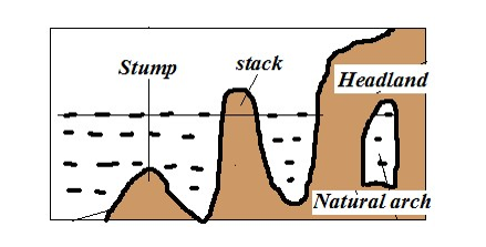
Natural arch – Opening from one side of a headland to the other. o Formed when a cave extends into the head land to the other side.
- Or when caves which have developed on both sides of headland join each other.
Stack – Pillar of rock left standing on the seaward side.
- Formed when continuous wave erosion causes the roof of the arch to collapse.
Stump – The base of stack left when it collapses as a result of erosion at the base.
Wave Transportation
Types of load moved by waves are such as shingle, sand, mud and other objects dumped into the sea.
How the sea acquires its load
- Materials brought by rivers and wind.
- Products Þ@^ú rivweathering.
- Materials brought by rivers and wind.
- Debris from volcanic eruptions in the sea or on land bordering the sea.
Waves transport load by a process called long shore drift. Long shore drift is progressive dragging of materials along the beach as a result of waves breaking at an angle. o Waves break at an angle.
- Swash pushes materials up the beach at an angle.
- Backwash brings them back at right angle to the edge of water.
- Process is repeated causing materials to be progressively dragged along the beach.
Factors Influencing Wave Transportation
1. Strength of waves
Strong waves carry large quantities of load over a long distance while weak waves carry small quantities of load over a short distance.
2. Tides
Tides cause waves to break farther inland causing materials that were not in contact with breaking waves to be moved about.
3. Ocean currents
Ocean currents cause movement of materials from one part of the ocean to another e.g. coconut fruits from southern part of Africa to Gulf of Guinea by Benguela current.
4. Gradient of the shore
On gentle coasts transportation of materials is favoured by long shore drift while on a steep coast they bounce off cliffs and remain floating.
5. Orientation of coast line.
Transportation by long shore drift is favoured where coast is aligned obliquely to the direction of breaking waves while on transversely aligned coast swash moves materials back and fourth along the same line.
6. Nature of the load.
Lighter materials such as sand are carried over long distances while heavy load is transported over a short distance.
Deposition
Process in which materials transported by waves are laid down on the shore.
Factors Influencing Wave Deposition
Load
Deposition occurs in selective manner:
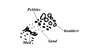
- Boulders are deposited at farthest end of land because they are swept towards the land by powerful swash during high tide followed by pebbles.
- Then sand and finally mud because the weak backwash brings them back towards the sea as they are light.
Waves
Waves must have a strong swash and a weak backwash in order to cause excess load to be left behind on the shore.
gradient of the shore
The coast must be sloping to reduce the velocity and hence the energy of waves so that depositing occurs.
Depth of Water
Deposition takes place where water is shallow for waves to come into contact with ocean floor and break the cyclic motion of water.
Features Resulting From Wave Deposition
Beaches
- Gently sloping mass of accumulated materials such as sand, shingle and pebbles along the coast. o Formed by constructive waves during a relatively calm weather when backwash is weakest resulting in materials accumulating at the shore.
During storms destructive waves destroy beaches creating other minor features such as:
Beach cusps
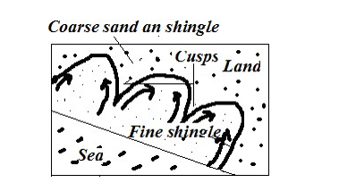
- Horn like projections of sand and gravel which gives the coast line a series of curves.
- Waves break at right angles.
- Powerful swash in form of eddies scour depressions moving coarse materials to either side forming head like projections called cusps leaving finer materials forming bay like inlets.
Beach Ridges and Beach Berms
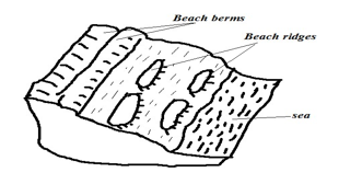
Beach Ridges – Low ridges of coarse sand, boulders and shingle deposited roughly parallel to the shore formed by waves approaching the coast at right angles.
Beach Berms
- Narrow terrace of shingle thrown up the beach by storm waves formed where tidal range is high.
Beach Rock Shells
Masses of sand, shells and pebbles cemented together by calcium carbonate forming projections above the beach.
Spits
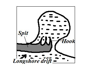
- Low lying ridge of sand, shingle and pebbles with one end attached to the coast and the other projecting to the sea.
- Movement of materials by long shore drift is halted causing deposition due to coast changing its direction towards the land e.g. across estuary or entrance of a bay.
- The process continues and the accumulation grows towards the sea.
- Waves carry sand to the inner end of the spit creating a hook like feature e.g. at the mouth of R. Senegal.
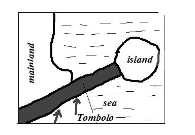
Tombolo
- Spit that grows out from the coast into the sea and joins an island e.g. Ras Hafur in Somalia and Ngomeni on Kenyan coast.
Bars
- Ridge of sand, shingles and mud which lies almost parallel to the coast.
Types
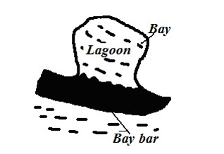
- Bay bar – Bar which forms across the entrance of a bay.
Offshore bar – Bar which forms off a very shallow coast line.
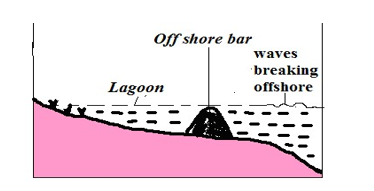
Wave is forced to break off shore due to water shallowness. o They throw up a ridge of materials off the coast.
Between the bar and the coast there will be a shallow lagoon colonised by marsh plants.
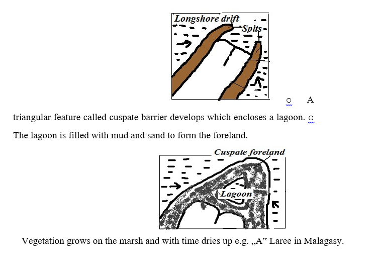
Cuspate foreland
- Broad triangular shaped deposits of sand or shingle projecting from the mainland into the sea.
- Two spits grow towards each other at an angle.
Dune Belts
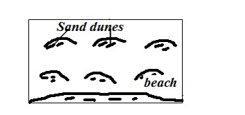
Belt of low lying mounds of sand found on extreme landward side of the beach above the high tide level. o Sand on the beach dries up during the high tide.
- It‟s picked by onshore winds and deposited at a distance away from the reach of breaking waves. o It collects behind obstacles like grass or other vegetation and gradually builds up forming a dune.
- The dunes may be covered with vegetation to form marshes.
Mud Flats and Salt Marshes
Mudflats – Platform of mud consisting of fine silt and alluvium deposited in sea inlets such as bays and river estuaries.
Salt marshes – Vegetation such as grasses and mangrove that grows on a mudflat o Fine silt and river alluvium are deposited in sea inlets by tides.
- A platform of mud builds up and is colonised by vegetation forming a swamp called salt marsh.
- The dense network of plants roots trap more mud and alluvium causing the mudflats to extend seawards.
Factors Determining the Type of Coasts
1. Wave action
Wave erosion makes a coast to have erosion features while deposition causes depositional features.
2. Tidal currents
Where tidal range is high more surface area is exposed to wave action.
3. Nature of rocks
Weak rocks are eroded to form bays (inlets) while resistant ones are left standing to form headlands.
4. Alignment of coast
There is more erosion on exposed coasts while deposition occurs where the coast is obliquely aligned to the breaking waves.
5. Change in sea level
Fall in sea level leads to emergence and rise to submergence.
Types of Coasts
According To the Alignment of Coast
1. discordant/transverse/irregular coast
- Coast which lies transversely to the coast line.
- Has a large number of inlets and receives heavy rainfall because winds blow onshore e.g. Mombasa.
2. Concordant coasts/regular/longitudinal coasts
One which lies almost parallel to the coastline.
Almost straight and lacks inlets and receives little rainfall due to winds blowing offshore e.g. Lamu.
According To Features Present
- Submerged Coasts – Coasts where a part of coastal land lies under the sea.
Causes of submergence
- Rise in sea level e.g. when large quantities of melt water were released to the sea causing its level to rise due to climate change at the end of ice age.
- Sinking of coastal land and a part of the sea floor.
Types
- Submerged Highland Coasts – Found where submergence occurs on a coast characterised by steep slopes.
Characterised by drowned features.
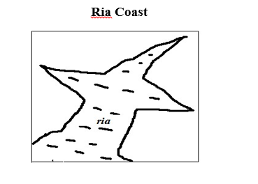
A Ria is a drowned river mouth.
Characteristics
- Funnel shaped
- U-shaped in cross section.
- Deeper and wider on the seaward side and shallower and narrower inland e.g. the Kenyan coast at Kilindini and Mtwapa.
2. Fiord/Fjord coast
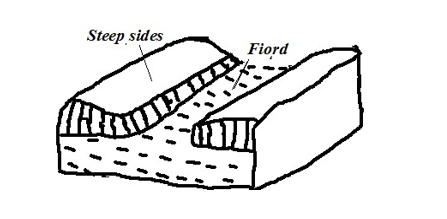
A fiord is a submerged glaciated valley.
- Ice deepens and widens glacial valleys until the floor lies below the sea level.
- When the ice retreats sea water flows in drowning the valley forming inlets called fiords.
Characteristics
- Deeper inland.
- Shallower at the sea ward end due to terminal moraine deposited when glacier was melting.
Longitudinal/Dalmatian Coasts – Coast where ridges and valleys lying parallel to the coast line are drowned.
- Valleys form inlets called sounds while ridges form islands.
Submerged Lowland Coasts
- Found where submergence occurs on a coast characterised by gentle slopes.
Types
1. Estuarine Coast
- Coast characterised by broad shallow estuaries and mud flats which are visible at low tide.
- Wider and shallower than rias e.g. coastlines of Guinea and Senegal
2. Fjard Coast
- Coast characterised by numerous inlets formed by submergence of glaciated rocky lowland coasts.
- Have numerous islands and are deeper than rias e.g. S.E. coast of Sweden.
3. Emerged Coasts
- Coast where part of seafloor has become permanently exposed.
Causes of Emergence
- Decrease in sea level due to decline in the source of water e.g. waters being held up in a glacier instead of it flowing back as rivers to the ocean.
- Uplift of the coastal land by faulting, folding or isostatic adjustment.
Types
Emerged Highland Coasts
- Found where emergence occurs on a coast characterised by steep slopes.
- Characterised wave action features which are isolated on land e.g. raised beaches, raised cliffs, raised wave cut platforms and raised arches.
Emerged Lowland Coasts
- Found where emergence occurs on a coast characterised by gentle slopes.
- Characterised by exposed depositional features e.g. spits and offshore bars which are found on land and a coastal plain formed as a result of a part of continental shelf becoming exposed.
Coral Coasts
- Coasts composed of coral rocks which are exoskeletons of marine organisms called coral polyps.
- They live in colonies/groups, feed on plankton and extract lime from the sea and build shells for protection.
Conditions Necessary for Coral Growth
- warm water(25-29◦C)
- Saline and clear water.
- Sunlight should penetrate at least to a depth of 50m to allow plankton growth.
- Plentiful supply of plankton which they feed on.
- Shallow water.
Types of coral reefs
Fringing Reefs
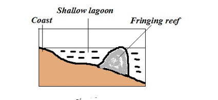
Platform of coral formed when coral polyps start building a reef near the shore.
Characteristics
- Flat or concave shaped
- Higher on the seaward side
- Outer edge falls steeply into the sea
Barrier Reefs
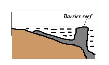
Platform of coral formed a long distance from the shore.
Formed when polyps start to grow and extend seawards where conditions are favourable.
Characteristics
- Its coral is joined to the shore.
- Its outer edge falls steeply into the sea.
Atoll Reef
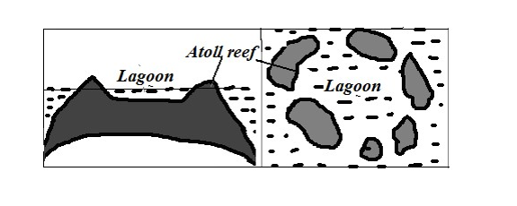
Coral ring formed around a submerged island.
Characteristics
- Circular in shape.
- Encloses a fairly deep lagoon.
Theories of Formation
Darwin’s Theory
- Fringing reef develops around an island. o The island starts to sink.
- Coral continues to grow upwards to keep pace with rising sea level and seawards because there is more food and water is clear.
- The reef extends great distance away from the land to become barrier reef.
- The island continues to sink becoming completely submerged. o The barrier reef forms a ring of coral called atolls.
Murray’s Theory
- Fringing reef grows on a submarine hill. o It disintegrates due to wave attack.
- Coral fragments accumulate on the seaward end.
- Polyps start building on it upwards where there is more food and clear water to form barrier reef.
- The barrier reef forms a ring of coral called atolls.
Daly’s Theory
- During ice age there was withdrawal of water causing global fall in sea level.
- Coral growth was retarded by low temperatures.
- Waves pounded coral reefs and islands and flattened them to the same level as the sea.
- At the end of ice age temperatures began to rise again favouring the growth of coral once again.
- More water was added to oceans causing polyps to continue to grow upwards to keep pace with the rising sea level.
- They were permanently exposed on the surface to form atolls
Significance of Oceans, Coasts and Coastal Features
Oceans Positive
- Influence climate by contributing the bulk of precipitation, warming effect in cool season and cooling effect in hot season by breezes and ocean currents.
- Used for transport by means of boats, steamers and ferries.
- Tourist attraction by beingsite for recreation e.g. swimming and sport fishing and marine life in parks such as in Mombasa and Lamu.
- Oceans are a source of fish which is a source of food, income and employment.
- Source of fresh water when its water is distilled.
- Tropical seas have mangrove forests with mangrove trees which provide strong building and fencing posts and tannin for tanning leather and also habitat for marine life which is a tourist attraction.
- Source of salt which crystallizes naturally after water evaporates in constricted bays in hot climates.
Negative
- Tsunamis from oceans flood the neighbouring coastal areas causing great loss of life and property.
- Oceans may also flood the neighbouring coastal areas as a result of rise in sea level caused by melting of glaciers caused by global warming.
- Also harbour dangerous animals such as sharks and crocodiles which may attack and hurt or kill people.
- Drowning accidents when there is breakdown of vessels or ship wrecking.
Coasts and Coastal Features Positive
- Fiords, rias and lagoons favour development of deep and well sheltered harbours.
- Fiords are also a good breeding ground for fish as their shallow continental shelf encourage growth of plankton which is food for fish.
- Coral rocks are used locally as building materials.
- Coral rocks are also a source of coral limestone for cement manufacture.
- Features such as coral reefs, caves, cliffs and fiords are a tourist attraction.
Negative
- Some emerged coastal lands have infertile soils unsuitable for agriculture for being covered by sand, gravel and bare rock.
- Deposited sands, bars and coral reefs are barrier to transport as they can cause ship wrecking if vessels hit them.
ACTION OF WINDAND WATER IN ARID AREAS
An arid area is a land which is deficient of moisture leading to scanty or no vegetation.
Action of Wind in Arid Areas Wind Erosion
Physical weathering is the initial process then it’s followed by wind erosion. Wind is more effective in tropical deserts due to:
- Presence of loose unconsolidated dry masses of mud, sand and gravel.
- Occurrence of strong tropical storms.
- Absence of vegetation leading to high wind velocity due to little frictional force.
Factors influencing wind erosion
- Wind speed– wind with high velocity has more energy to erode than with low velocity.
- Load– angular shaped load provide more effective abrasive tools than one which is round shaped.
- Nature of surface– Wind erosion is faster where the surface consists of unconsolidated materials.
Processes/Ways in Which Wind Erodes Deserts
1. Abrasion
- Materials carried by wind such as sand grains scratching rock surfaces across the path of wind.
- Greater close to the ground because it‟s where heavy and more effective abrasion tools are lifted and carried.
2. Deflation
- Removal of unconsolidated materials such as sand and dust rolling and lifting or scooping and blowing away.
3. Attrition
- Sand grains carried by wind knocking against each other causing each other to become smaller and rounded in shape.
Resultant Features of Wind Erosion
1. Millet seeds
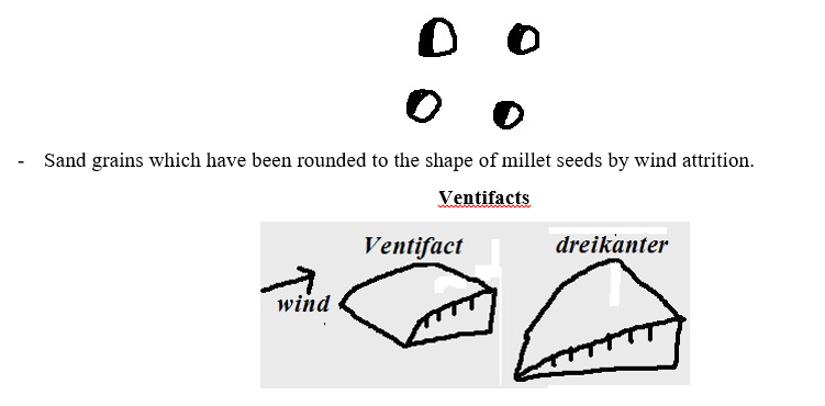
- Boulders, stones and pebbles which are flattened by wind abrasion one or more sides due to changes in wind direction.
- Dreikanter – Ventifact with three wind faceted surfaces formed when wind is blowing in different directions.
Mushroom Block
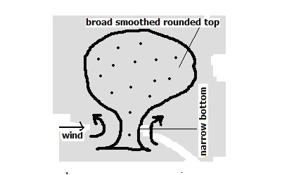
- Mushroom shaped rock in desert landscape. o Wind abrasion acts on a rock with uniform hardness.
- It‟s intensely undercut at the base and top part is slowly polished by light and less effective abrasive materials.
- There results a rock with broad smoothed rounded top and a narrow base resembling a mushroom
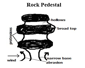
- Irregular rock pillar with a broad top and a narrow base found in the desert landscape.
- Wind abrasion acts upon rock with alternating hard and soft layers.
- Soft layers are eroded more than hard layers leaving hollows and protrusions.
- There is more undercutting at the base where there is more abrasion.
- There results an irregular rock with a narrow base.
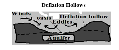
- Shallow depressions found in desert landscapes formed by deflation.
- Wind scoops and blows away unconsolidated materials such as dust and sand in a desert.
- Circulating wind deepen the depression.
- The hollow reach the water table forming an oasis.
- If the depression doesn‟t reach the water table flash floods water may accumulate into them to form temporary lakes called pans e.g. Etosha pan in Namib.
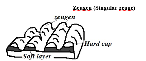
- Ridges on a ridge and furrow desert landscape.
- First there is a landscape with horizontal alternating layers of hard and soft rocks.
- Weathering opens joints and cracks on the top resistant layer.
- Abrasion erodes the opened joints while deflation carries away the eroded materials.
- The process continues and with time causes a ridge and furrow landscape to develop. The ridges are zeugen.
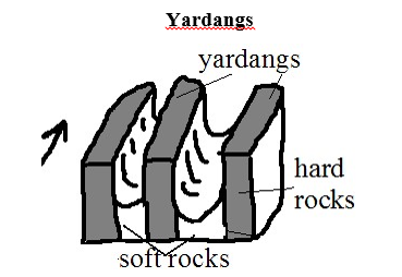
- Narrow elongated rock ridges about 6m high on a desert landscape.
- At first there is a surface with vertical alternating hard and soft rocks lying parallel to wind path.
- Wind abrasion acts more on soft rocks and deflation carries away worn out particles.
- The undercut rocks are left standing forming ridges called Yardangs.
Wind Transportation
Factors Influencing Wind Transportation and Deposition
Wind velocity: when speed decreases strength also decreases and its ability to transport so wind starts to deposit materials.
- Wind direction- Winds blowing from different direction converge and cause load to collide causing some of it to be deposited.
- Nature of desert surface:
- Wind transportation is more efficient on bare surfaces and hence less deposition there.
- Water surfaces such as oasis and moist surfaces impede transportation through friction causing wind to deposit materials.
- Less transportation on surfaces with vegetation as it reduces wind speed and also binds sand particles together.
3. Obstacles- Objects such as rock masses, land forms and vegetation block and reduce wind speed causing deposition.
4. Changes in weather conditions such as sudden showers halts transportation and causes deposition by washing down suspended materials.
5. Load- Heavy load is deposited before light load when wind energy decreases. When many materials are transported by wind they collide causing each other to be deposited.
Processes/ Ways in Which Wind Transports Load
1. Suspension
- Wind lifting and holding particles such as dusts by air currents and transporting them over long distances.
2. Saltation
- Wind transportation of heavy particles by a series of jumps and hops.
- They are rolled.
- They collide.
- Bounce and get lifted.
- Transported short distance ahead.
3. Surface Creep
Wind transportation of heavy particles such as gravel and pebbles by pushing and rolling along the desert.
Resultant Features of Wind Deposition
- Sand Dunes Dune – Low ridge of sand accumulated by wind deposition.
Types
Barchans
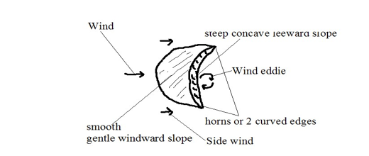
Crescent shaped mound of sand in a desert.
- Sand accumulates around an obstacle lying on the path of wind.
- Deposition continues making the mound to grow bigger.
- Wind blows sand over leeward side creating smooth gentle windward slope.
- Wind eddies act on the leeward slope making it to be steep and concave in shape.
- Side wind move the sand grains on the sides forward creating the two edges which are curved e.g. in Sahara and Arabian Deserts.
Characteristics
- Crescent/moon shaped
- Smooth gentle windward slope
- Steep concave leeward slope
- Horns or 2 curved edges
Occurs individually or in groups
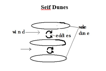
Ridge shaped mounds of sand lying parallel to the path of prevailing wind. o Wind blows between barchan dunes.
- Wind eddies move sand towards the sides.
- Sand accumulates on the sides resulting into ridge shaped mounds e.g. in Namib Desert.
Transverse/Wake Dunes
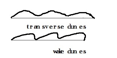
Wave like mounds of sand in a desert which lie at right angles to the prevailing wind.
- Less strong winds blow over sand from one direction.
- The wind concentrates larger grains of sand into series of transverse ridges.
- Wind may continue pushing the sand causing it to accumulate on the leeward side to form wake dune e.g. in W. Sahara.
- Drass
- Biggest sand features in a desert with surface resembling a plateau and with a height of up to 200m.
- Barchans and Seif dunes may form on such features e.g. in E. Sahara desert.
- Loess
- Fertile soils with great thickness of about 100m formed from deposition of dust from deserts. o Dust from deserts is carried beyond to wet areas.
- It‟s washed down by rain causing its deposition.
- It accumulates into layers.
- Deposition continues and the layers are compacted forming sedimentary rocks.
- The sedimentary rocks wither to form fertile soils which favour cultivation e.g. Temperate lands of Europe along Rhine valley from Sahara dusts and along Huang He valley in N. China from dust of Gobi desert.
Action of water in arid areas
- Receives short occasional rains causing flash floods which erode transport and deposit large loads of materials produced by weathering.
- Water action is short lived.
Resultant Features of Water Action in Arid Areas
-
Wadis
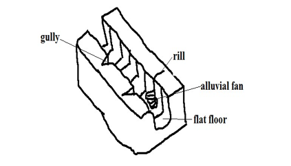
- Wide deep steep sided dry valley in a desert o Strong surface runoff and flash floods form rills.
- Rills are enlarged into gullies.
- Flash floods flow into gullies widening and deepening them to form wadis.
Characteristics
- Wide and deep
- Steep with cliff like walls o flat floor
- Dry (lack permanent drainage)
2. Dry River Valleys
Valleys in arid areas through which streams flow during the wet season and dry up in dry season e.g. in Turkana, Wajir and Mandera.
3. Mesas and Buttes
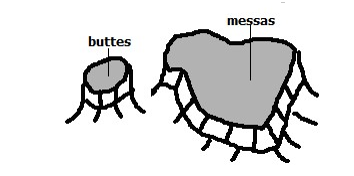
Mesas – Extensive table like residual hills found in arid areas.
Buttes – Smaller blocks of table like residual hills found in arid areas.
- First there are sedimentary rocks occurring in layers with a resistant one on top and a less resistant below.
- Weathering breaks the hard cap.
- Then sheet floods break the surface and carries materials away.
- Large outstanding blocks are left which are called mesas.
- Mesas may be eroded farther to form smaller blocks called buttes.
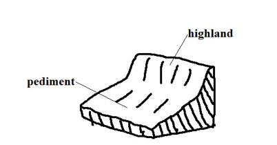
Gently sloping rock surface formed at the edges of desert uplands.
- A steep/scarp slope of a highland is eroded by sheet flooding reducing its height.
- The process continues causing the scarp slope to shift its position upwards.
- The gently sloping surface of 6-7◦results at the foot of the upland.
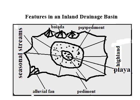
4. Playas/sebkha
- Extensive inland drainage basin in a desert formed by deflation or crustal warping or a small fluctuating salty lake contained in an inland drainage basin in a desert formed when water from torrential outpours flows into the basin by multiple temporary streams e.g. Chemchane sebkha in Mauritania.
5. Peripediment
- Zone of thick alluvial deposits at the edge of playas in form of alkaline crust of mud, sand and gravel formed when streams deposit a lot of materials at the edge of the playa. Materials dry up leaving a hard salty crustal surface called Salina/salar g. in Arizona desert in U.S.A.
6. Pediment
7. Peneplain
Low level plain formed when pediments are eroded to form a low level plain.
8. Pediplain
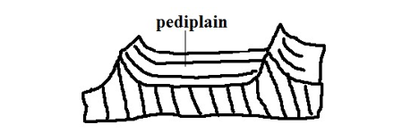
- Extensive low and gently sloping lands common in deserts.
- Pediments surrounding a highland are extended by sheet erosion.
- With time the highland is reduced to a residual hill like Inselbergs.
- The hill is eventually eroded forming a continuous plain(Pediplain)
9. Inselbergs – Prominent residual rocks in a desert.
Formed by extension of pediments into upland areas.
Types
Bonhardt – Steep isolated round topped mass of rock rising steeply from desert surface.
- Dissection of plateau by streams producing steep sided valleys.
- The plateau is further eroded forming remnant hills e.g. Sugar Loaf Mountain in Rio de Janeiro in Brazil.
Castle kopje – Residual rocks in a desert found in groups.
- Formed from break down of Bonhardt with closely spaced joints. o Or deep withering of a plateau edges.
- Weathered rocks are then removed by water reducing plateau into Inselbergs e.g. Nzambani rock in Kitui.
Significance of Deserts and Desert Features
Positive
- Loess soils are used for agriculture because they are very fertile e.g. in Huang He valley and Ukraine.
- Loess soils in Europe and china have dug in caves which are inhabited during winter to provide warmth.
- Desert features are a tourist attraction e.g. rock pedestals, Yardangs, Zeugen and sand dunes.
- Oasis in deflation hollows are sources of water for domestic use.
- Oasis water is also used for irrigation such as of date palms.
- Deserts are good sites for testing military weapons, military training and experimenting ground for aircraft because they are sparsely populated.
- The scarce vegetation in deserts such as shrubs can be used in livestock keeping e.g. goats, camels etc.
- The hot sun in deserts can be harnessed to provide electricity for lighting, pumping of water, etc.
- Seasonal streams can be dammed to supply water to surrounding areas e.g. Kigombo dam in Mbororo in Taita which supplies water to Voi town.
Negative
- Some desert features can prevent physical development e.g. sand dunes can burry roads and it is difficult to construct bridges across wadis.
- Sand dunes can cover oasis and settlements.
- Sand dunes may destroy rich agricultural land.
- High temperatures, shortage of water, unreliable rainfall and lack of transport and communication infrastructure discourage settlement.
UNDER/GROUND WATER
- Water that exists beneath the earth‟s surface in pore spaces in soil and rocks.
Sources of Ground Water
1. Rain Water
- Some rain water which percolates and is trapped after meeting an impermeable rock.
2. Melt Water
- Water that infiltrates into the ground when snow melts during spring and summer.
3. Surface Water
- Water from rivers, seas, swamps, oceans, lakes and ponds that seep into the ground.
4. Magmatic/Plutonic Water
- Water trapped in rocks beneath surface during vulcanicity
Factors Influencing Existence of Ground Water
1. Precipitation
- For ground water to exist precipitation must exceed evaporation.
- Light rain falling over a long period of time infiltrates more than heavy short lived downpour.
2. Slope
- On flat and gently sloping areas rain water has ample time to infiltrate because it remains in one place for a long time.
- On steep areas there is low infiltration since a lot of water turns into runoff because of getting less time to percolate.
3. Nature of Rocks
- There is a greater possibility of existence of ground water where there are permeable surface rocks.
- Ground water exists where impermeable rock overlie an impermeable one so that when water infiltrates
and percolates underground it‟s trapped by impermeable rock and accumulates above it. Aquifer – permeable rock which is permanently saturated with water.
Permeable rocks – Rocks which allow water to pass through them.
Types
- Porous – Those with pores/airspaces between rock grains through which water passes e.g. sandstone, limestone and chalk.
- Pervious – Ones with cracks fractures and joints through which water enters and passes e.g. granite, limestone and chalk.
Impermeable rocks – Ones which don‟t allow water to pass through them.
Types
- Aquifuge – Impenetrable impermeable rocks e.g. gabbro, shale and slate.
- Aquiclude – Porous rocks which absorb water and expand narrowing air spaces between grains preventing water to percolate downwards e.g. clay.
- Vegetation Cover
- Plants break the speed of rain drops causing drops to hit the ground gently giving rain water ample time to percolate.
- On bare surfaces most of precipitation flows away as run off.
4. Level of Saturation of Ground
- Infiltration is more on dry ground because it has wide open air spaces while and less on a ground whose air spaces are saturated with water.
Water Table
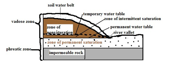
- Water that infiltrates and percolates into the ground fills air spaces creating zones of saturation whose upper levels are called water tables.
Zones of Saturation
Zone of Non-saturation
- Zone of permeable through which water passes but doesn’t remain in the pores for a long time.
- Well sunk to this zone doesn’t contain any water.
Zone of Intermittent Saturation
- Zone which during the rain season the rocks are saturated with water while during the dry season they are unsaturated.
Temporary water table – Upper level of ground water in the zone of intermittent saturation.
- Zone of non-saturation and that of intermittent saturation are called vadose zone.
Zone Of Permanent Saturation – Zone where pores spaces are permanently filled with water.
Permanent water table – Upper level of ground water in the zone of permanent saturation.
Presence of ground water leads to formation of springs, wells boreholes and artesian basins.
Springs
Place where water flows out naturally onto the earth’s surface along a slope.
Ways/Modes Formation
- Hillside Spring
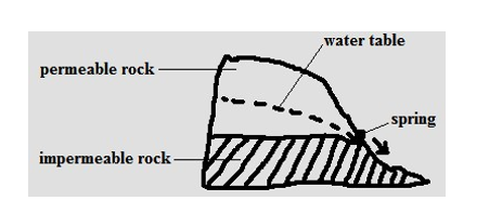
- Type formed where a permeable rock lies above an impermeable one on a hill and water comes out at the junction of those two rock layers.
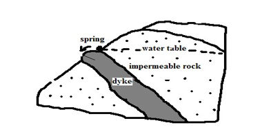
2. Dyke Spring
- Type formed where an igneous dike cuts across a layer of permeable rock. o Ground water on the upslope side is trapped causing water table on that side to rises.
- A spring develops where the water table is exposed on the surface.
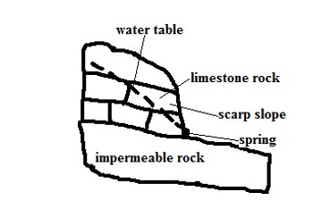
3. Vauclusian Spring
- Type formed on a limestone hill or escarpment overlying an impermeable layer.
- Limestone rock becomes saturated with water.
- Water comes out of the ground where water table appears on the surface.
4. Valley Spring
- Type formed where water table intersects the surface along the side of the valley.
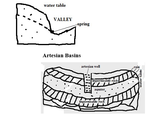
Saucer shaped depression consisting of a layer of permeable rock sandwiched between two impermeable rocks and the whole system forms a syncline.
Characteristics
- One or both ends are exposed on the surface on a rainy area or beneath a lake.
- Water enters at the exposed end or ends.
- With time the permeable rock is saturated with water and becomes an aquifer e.g. between Chad and Egypt across Quattara depression.
Artesian well
Well sunk into the aquifer of an artesian basin from which water will come out without being pumped.
Ideal Conditions for Formation of an Artesian Well
- Aquifer to be sandwiched between impermeable rocks to prevent evaporation and percolation.
- Aquifer to be exposed in a region which is a source of water e.g. rainy area or lake.
- Aquifer to dip from the region of water intake.
- Mouth of the well to be at a lower level than the intake area to develop hydraulic pressure which will force water out.
Problems Associated With Artesian Wells
- Water may be hot due to high temperatures.
- Water may be salty because of water taking long to percolate through rocks thus dissolving large quantities of mineral salts.
- Water may fail to come out naturally when water is drawn faster than it‟s being replaced in the source region and necessitating pumping.
Significance of Underground Water
- Source of rivers and their tributaries.
- Source of water for domestic and industrial use e.g. wells, springs, boreholes and oasis.
- Used in agriculture e.g. oasis water is used for irrigation of date palms.
- Influences settlements due to the availability of water e.g. in deserts people settle near oasis and spring line settlements in limestone areas.
- Hot springs are a tourist attraction and their water is trapped and pumped into houses through pipes for heating during winter e.g. in Iceland.
- Underground streams help in keeping some lakes fresh e.g. L. Naivasha.
Action of Water in Limestone Lime stone Areas (Karst Region) Karst region – Region where the surface and the ground is covered with limestone rocks.
Karst scenery – Unique features in a Karst region resulting from the action of water e.g. Shimoni caves at the coast of Kenya.
– When calcium carbonate is exposed a weak carbonic acid formed by rain dissolving CO2 it‟s dissolved to form calcium hydrogen carbonate which is removed from the rock in solution resulting in surface and underground features in such a limestone region.
Factors Influencing Development of Karst Scenery
- Surface rock and the rock below should be hard and well jointed for acid water to percolate and cause solution to happen e.g. limestone, chalk or dolomite.
- Climate should be hot to speed chemical weathering and humid for availability of rain which is a solvent.
- Should have a lot of vegetation to release CO2.
- Water table to be far below the surface so that the whole limestone rock is not dissolved and underground features fail to be formed.
Surface Features in Limestone Areas
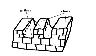
- Grikes and Clints
Clints – Blocks of limestone rock left standing when water infiltrates through the limestone rocks widening and deepening the joints.
Grikes – Deep groves or gullies formed when rainwater infiltrates through limestone rocks widening the joints by solution.
2. Swallow/Sink Holes
- Deep vertical holes formed on limestone rocks when solution extends the grikes.
- Referred to as swallow/sink holes because surface runoff or river water may disappear through them as a waterfall and come out of the ground as a vauclusian spring further downhill.
- Vertical shaft from the surface of the sink hole down into the ground is called ponor.
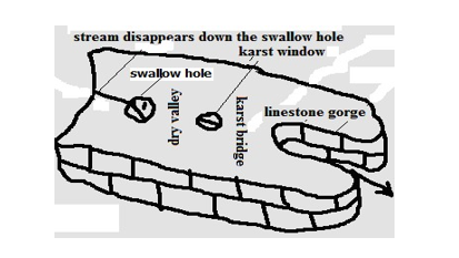
3. Dry Valley
- Steep valleys with no permanent streams on limestone surface at the section between the swallow hole and where the river emerges.
4. Karst Window
- Small outlet to the surface from a cavern formed when continuous carbonation at the surface causes the roof of the cave to collapse.
5. Limestone Gorge
- Deep steep sided river valley in limestone rocks formed when the swallowed river causes solution to continue underground causing the roof of underground water course to collapse.
6. Karst Bridge
- Small section left joining the roof between the karst window and gorge.
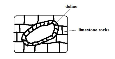
7. Dolines
- Elliptical hollow with gently sloping sides on the surface of a limestone region formed when several swallow holes collapse and merge.
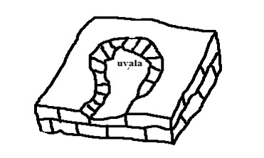
8. Uvala
Depression which may be as wide as 1 km in diameter formed on the surface of limestone regions when several dolines collapse and merge.
Polje
- Largest, shallow, elliptical and flat floored depressions on a limestone region formed when several uvalas collapse and merge.
- May become a temporary lake or may be covered by a marsh.
Underground Features in Limestone Areas
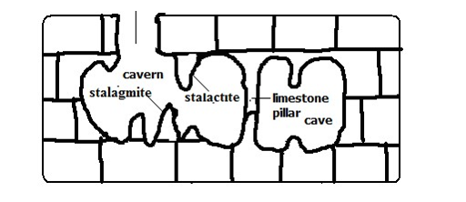
Stalactites
- Finger like masses of calcite hanging vertically from the roof of a limestone cave or cavern formed by repeated evaporation of water and giving off of carbon dioxide from drops of water containing calcium bicarbonate hanging from the roof of the cave causing crystallisation of calcium bicarbonate into calcite.
Stalactite
- Stumpy rock masses of calcite which grow from the floor of a limestone cave upwards formed by repeated dripping of solution of calcium bicarbonate from the end of stalactite to the floor of a limestone cave then it spreads out and crystallizes.
Limestone Pillars
- Pillar like structures in limestone caves formed when stalactites and stalagmites grow towards each other, stalagmite grows until it touches the roof of a cave or when a stalactite grows until it touches the floor of the cave.
Limestone caves – Underground chambers or cavities in limestone rocks.
- Underground rivers dissolve limestone in horizontal joints forming a horizontal tunnel.
- Surface water and underground water percolates through the joints into the tunnel enlarging it forming a phreatic cavee. cave below the water table.
- The water flows out at the vauclusian spring lowering the water table causing the phreatic cave to become a limestone cave.
- Continued solution from water percolating through the caves roof widens and lowers its floor to form a larger cave called limestone cavern e.g. Carls band cave in New Mexico U.S.A.
Significance of Karst Scenery
Positive
- Features in karst scenery are a tourist attraction e.g. caves, gorges, stalactites, stalagmites, etc.
- Limestone rock is used in the manufacture of cement e.g. cement factory at Bamburi in Mombasa and Athi River.
- Limestone blocks are also used for building.
- Limestone regions are very good for grazing particularly sheep because the surface is dry.
- Large villages called spring line settlements form at the line of vauclusian springs due to the availability of water.
Negative
- Limestone landscape discourages settlement because the surface is rocky, soils are thin and unsuitable for agriculture, surface is rugged with features like grikes and Clints and the water supply is inadequate due to rivers disappearing into swallow holes.