
- Action of moving ice.
Glacier – Mass of ice moving outward from an area of accumulation.
- Formed when snow accumulates on the surface, lower layers are compressed to a harder mass resulting in opaque ice due to air bubbles and accumulation continues compression lower layers squeezing out air forming glassy ice called glacier.
Types
- Cirque glacier – ice occupying a cirque.
- Valley glacier – Ice confined within a valley
- Piedmont glacier: Glacier formed when valley glaciers converge at the foot of the mountain.
Ice bergs – Large mass of ice floating in the ocean formed when an ice sheet moves to the sea e.g. in Arctic and N. Atlantic Ocean.
Ice sheet – Continuous mass of ice covering a large area on the earth’s surface.
Ice caps – Ice covering the mountain peak.
Snow line – Line beyond which there is a permanent snow cover.
Ways of Ice Movement
1. Plastic Flowage – Movement of ice like a viscous liquid.
- Great pressure is exerted at the bottom sides and centre causing some ice particles to melt slightly and move slowly down hill like a viscous liquid.
2. Basal Slip – Movement of ice by sliding over the underlying rock. o Pressure is exerted on deepest layers of ice in contact with the rock beneath causing melting.
- A film of water is created which acts as a lubricant between the ice and the rock causing ice to slip and slide over the rock and move down slope.
3. Extrusion Flow – Movement of ice by spreading out.
- Ice accumulates building to great thickness at the centre causing compression of layers of ice beneath.
- The layers beneath are forced to spread out where there is less pressure.
4. Internal Shearing – Breaking of ice into smaller pieces which move alongside one another.
- Uneven movement causes ice to develop cracks on the surface.
- The glacier breaks into smaller pieces which move alongside each other down slope.
Factors Influencing Ice Movement
1. Gradient of the Land
Ice moves faster on steep slopes than on gentle slopes due to the influence of gravity.
2. Season
Ice movement is faster in summer due to frequent thawing melting compared to winter when thawing is rare.
3. Friction
Central parts of ice move faster than sides and bottom which are in contact with rock beneath due to friction.
4. Thickness of Ice
Thicker masses of ice cause more pressure between them and rocks beneath which cause slight melting and therefore faster movement.
Glacial Erosion
Processes/Ways in Which Ice Erodes
1. Plucking
- Pulling away of parts of a rock at the base of glacier when the ice freezes into the cracks of a well jointed rock.
2. Abrasion
- Scratching of the underlying ground by stones and boulders carried by the ice as the glacier moves.
Factors Influencing Glacial Erosion
1. Nature of Underlying Rock – Abrasion is more effective on soft rocks than hard rocks.
- Well jointed and faulted rocks are more eroded than those which are not because cracks and joints enable water to enter rocks and freeze which facilitates plucking.
2. Gradient of Slope
- Glacier on steep slopes moves faster and has greater kinetic energy to erode than slow moving glacier
3. Thickness of Ice
- Thick ice is heavier and exerts greater pressure on rock debris making them to abrade the underlying rock more effectively.
4. Availability of Debris
- The more the rock debris the more effective abrasion will be since it acts as abrasive tools.
- Too heavy debris makes erosion impossible since ice is not able to transport it but glides over it without acting on the rock below.
Erosion Features
On Glaciated Highlands
1. Cirque
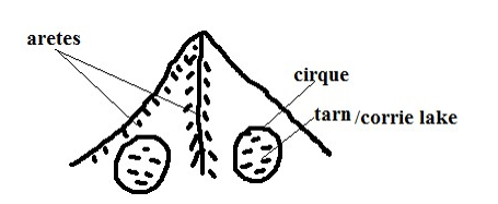
- Arm chair shaped depression on glaciated slopes of high mountains.
- Snow accumulates into a shallow depression on the side of a mountain.
- Freezing in winter and thawing in summer causes rocks to wither and break up resulting in enlargement of the hollow.
- Accumulated ice advances by slipping down slope.
- A deep crevice called bergshrund develops at the top of ice due to unequal movement.
- Freezing occur deep down the bergshrund causing the back wall and sides to be steepened by plucking.
- Plucked debris is carried forward scratching the floor of the basin deepening it forming the cirque, corrie or cwm. o Water from melting snow may accumulate in a cirque to form a tarn e.g. Teleki tarn.
2. Arêtes
- Narrow knife- edged steep ridge separating two cirques.
- Formed when two cirques cut backwards on adjacent sides of a mountain leaving a narrow steep ridge separating them.
3. Pyramidal Peaks – Sharp steep sided peak at the top of a mountain.
- Formed when three or more cirques erode on mountain side towards each other leaving a sharp pointed rock separating them at the top of the mountain e.g. Corydon and Delamere on Mt. Kenya.
4. Glacial Trough
Glacial Trough and Related Features
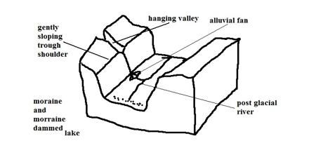
- Wide flat bottomed valley with steep sides on a glaciated highland.
- Ice accumulates in a v-shaped valley.
- Plucking and abrasion by ice occurs.
- The v-shaped valley is deepened, widened and straightened to become a glacial trough.
- Glaciated trough may be submerged to form a fiord.
5. Truncated Spurs
- Interlocking spurs of former river valleys which are eroded and straightened by valley glacier.
Erosion Features on Glaciated Lowlands
- Roche Mountonnee
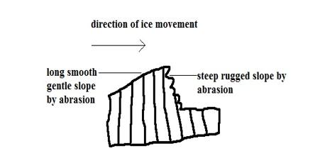
- Rock outcrop with a long smooth gentle slope on the upstream side and a rugged steep slope on the down stream side found on glaciated lowland.
- Formed ice acts on a rock on its way causing the side facing the upstream side to be polished by abrasion resulting into a smooth gentle slope and the down stream side is affected by plucking resulting in a rugged steep slope leaving a rock outcrop standing just above the surface.
2. Crag and Tail
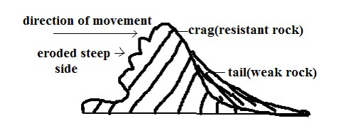
Crag – projection of resistant rock which protects a mass of softer rock on the downstream side of the glacier.
- The ice moves over and around over the resistant rock eroding it slightly by abrasion.
- Cracks develop on the upstream side causing the ice to move and pluck materials from the resistant rock leaving a projection of resistant rock with a steep rugged upstream side is formed.
Tail – elongated feature on the downstream side of the crag formed by formed by material deposited by the glacier on the downstream side and the weaker rock.
Depressional Lakes
- Depressions filled with water from melting ice found in glaciated lowlands.
- Formed when soft rocks are scooped out by moving ice sheet forming depressions which are filled with water to form a lake.
Glacial Deposition – Material carried by the glacier is called moraine.
Types of Moraine
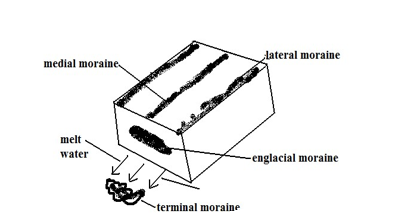
- Ground/sub-glacier moraine – load carried at the base of the glacier.
- Englacial moraine – load within the glacier.
- Lateral moraine – load carried at the sides of the glacier.
- Medial moraine – load carried in the centre of the valley by glacier.
- Terminal/recessional moraine – load deposited at the point where a glacier melts.
Types of Glacial Deposits/Drift:
- Till – directly deposited by ice on melting in unstratified manner.
- Fluvial – materials deposited by water from the melting ice in stratified manner.
Causes of Glacial Deposition
1. Amount of glacial drift
When ground moraine is too much the glacier glides over it leaving it behind.
2. Weight of glacier
When more ice is added to a stationary glacier pressure is exerted at the base causing melting and the material which was embedded in the ice is dropped.
3. Climatic change
During summer and spring ice melts depositing some materials the glacier was carrying.
4. Friction beneath the ice
Friction between ice and surface reduces ice speed causing heavy materials to be deposited beneath ice sheets.
5. Slope
Lowlands allow glacier to accumulate a lot of materials which are finally deposited by melting ice.
Features Resulting From Glacial Deposition
1. Till Plain
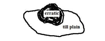
- Extensive area of flat relief resulting from burying of former valleys and hills by glacial deposits.
2. Erratics
- Large boulders of resistant rocks transported by glacier from highland and deposited on the till plain.
3. Drumlins
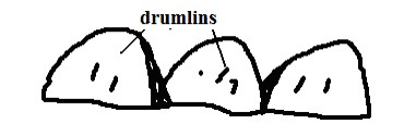
- Long egg shaped hills deposited and shaped under an ice sheet of very broad glacier.
- Glacier deposits boulder clay at the valley bottom due to friction between the bed rock and the boulder clay.
- With more deposition large mounds of deposits are formed.
- The moving ice streamlines the till that has been deposited irregularly resulting into the upstream sides of the till being steep but smoothed.
4. Terminal Moraine Ridge
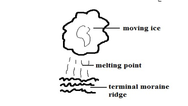
Ridge like feature formed by extensive deposition of moraine along the edge of an ice sheet.
- Ice remains stagnant for a very long time.
- The ice at the edges of sheet melt and a lot of materials are deposited.
5. Eskers
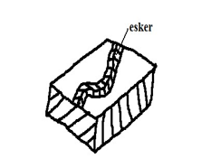
- Long winding ridge composed of gravel formed by glacial deposition.
- Streams carrying large amounts of load flow fast in a sub-glacial tunnel parallel to the direction of moving ice.
- When the ice melts the tunnels collapse causing streams to slow down and deposit much of the load forming a ridge.
6. Kame
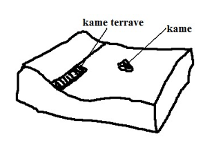
- Isolated hill made of sand and gravel which have been deposited in strata by glacial water.
7. Kame Terrace
- Ridge of sand and gravel occurring in narrow lakes that exist between the glacier and an adjacent highland.
8. Outwash Plains
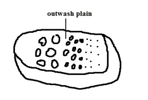
- Wide gently sloping plain composed of gravel and sand formed by glacial deposition.
- Formed when finer materials of terminal moraine are deposited in very thick layers over an extensive area forming a plain.
Significance of Glaciation
Positive
- Some outwash plains have fertile morainic soils suitable for agriculture e.g. Canadian prairies where wheat is grown.
- Water falls on hanging valleys are used for generation of H.E.P.
- Glaciated highlands are a tourist attraction especially during winter when sporting activities such as skiing and ice skating are carried out.
- Glacial lakes such as great lakes of N.America provide natural route ways and fish sources e.g. L.Superior and Huron.
- Glaciated mountains are catchment areas for permanent rivers.
- Sheltered water of fiords is a suitable bleeding ground of fish as natural harbours.
- Sand excavated from outwash plains and eskers is used for construction.
Negative
- Land in glaciated areas can’t be fully utilised for agriculture due to being marshy because of boulder clay deposits e.g. central Ireland.
- Infertile sands deposited in outwash plains make land unsuitable for agriculture.
- Numerous lakes formed as a result of morainic deposits reduce the land available for agriculture.
- Settlement and transportation in glaciated landscape is difficult due to ruggedness caused by glacial action.