

KCSE Past Papers 2016 Geography Paper 1
2016 Geography Paper 1
SECTION A (30 marks)
Answer all the questions in this section.
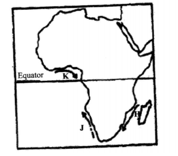
1. (a) How does a sea breeze occur? (b) Use the map of Africa below to answer question (b) (i) (2 marks)
(i) Name the ocean currents marked H, i and K. (3 marks)
(ii) State two effects of a warm ocean current on the adjacent coastlands. (2 marks)
2. (a) Name two types of boundaries according to the plate tectonic theory. (2 marks)
(b) Give three effects of the movement of tectonic plates. (3 marks)
3. The diagram below represents the structure of the atmosphere. Use it to answer question (a).
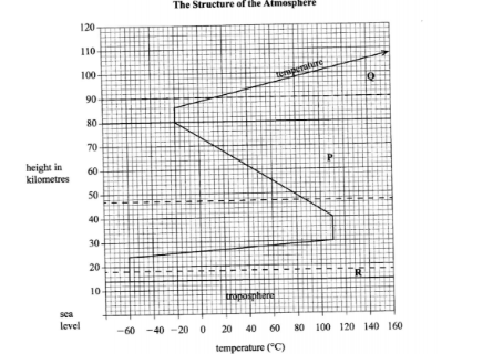
(a) Name: (i) The parts marked P and Q.
(2 marks)
(ii) The layer of discontinuity marked R. (1 mark)
(b) State two characteristics of weather conditions in the troposphere. (2 marks)
4. The diagram below shows coastal features.
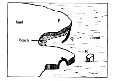
(a) Name the features marked P, Q and R. (3 marks)
(b) State two conditions necessary for the formation of a beach. (2 marks)
5. Name the three major deserts in Africa. (3 marks)
SECTION B
Answer question 6 and any other two questions from this section.
6. Study the map of Kitale 1:50,000 (sheet 75/3) provided and answer the following questions.
(a) (i) Identify two human made features found at the grid square 2320. (2 marks)
(ii) What is the altitude of the highest point in the area covered by the map? (2 marks)
(iii) Give three types of natural vegetation found in the area covered by the map. (3 marks)
(b) (i) What is the bearing of the air photo principal point at grid square 3426 from the air photo principal point at grid square 2931? (2 marks)
(ii) Measure the distance of the dry weather road (C640) from the junction at point M (345142) from the junction at point N (416201) Give your answer in kilometers. (2 marks)
(c) (i) Using a scale of 1 cm to represent 40 metres, draw a cross-section from grid reference 410180 to grid reference 500180. (4 marks)
(ii) On the cross-section mark and name the following:
• a dry weather road; (1 mark)
• River Kaptarit (1 mark)
• a ridge. (1 mark)
(iii) Calculate the (VE) vertical exaggeration of the section. (2 marks)
(d) Citing evidence from the map, identify five social services offered in Kitale. (5 marks)
7. (a) (i) Name two types of submerged highland coasts. (2 marks)
(ii) Identify two resultant features of the emerged highland coasts. (2 marks)
(b) State three factors influencing deposition by ocean waves. (3 marks)
(c) With the aid of labelled diagrams, describe the formation of the following coastal features:
(i) Fringing reef; (5 marks)
(ii) Spit. (5 marks)
(d) Explain the significance of oceans to human activities. (8 marks)
8. (a) (i) What is a lake? (2 marks)
(ii) Name two crater lakes in Kenya. (2 marks)
(b) Describe how each of the following lakes are formed: (i) come lake; (4 marks)
(ii) oasis; (4 marks) (iii) lagoon. (4 marks)
(c) (i) Give three reasons why some lakes in Kenya have saline water. (3 marks)
(ii) Explain how each of the following has affected lakes in Kenya:
• deforestation (2 marks)
• industrialisation (2 marks)
• water needs. (2 marks)
9. (a) (i) Name three types of faults. (3 marks)
(ii) Apart from compressional forces, explain two other processes that may cause faulting. (4 marks)
(b) With the aid of diagrams. describe how compressional forces may have led to the formation of the Great Rift Valley. (8 marks)
(c) Explain five ways in which faulting is of significance to human activities.(10 marks)
10. (a) Differentiate between magma and lava.
(b) The diagram below shows some intrusive volcanic features.(2 marks)
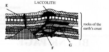
Name the features marked E, F, and G. (3 marks)
(c) Describe how the following features are formed and for each give an example from Kenya:
(i) a crater (3 marks)
(ii) a geyser (5 marks)
(iii) a lava plateau. (4 marks)
(d) Explain four ways in which volcanic features influence human activities. (8 marks)