
 UNIVERSITY EXAMINATIONS: 2010/2011
SECOND YEAR STAGE EXAMINATION FOR THE DEGREE OF BACHELOR
OF SCIENCE IN INFORMATION TECHNOLOGY
BIT2307: GEOGRAPHIC INFORMATION SYSTEMS
DATE: AUGUST 2011 TIME: 2 HOURS
INSTRUCTIONS: Answer question ONE and any other TWO questions
Question One (30 Marks)
a) Distinguish between the following geographic concepts;
i) Digitizing and cartography (2 Marks)
ii) Spatial data and attribute data (2 Marks)
iii) GPS and CAD (2 Marks)
b) Establish the benefits of using electronic maps as opposed to paper maps (6 Marks)
c) Discuss how the ‘human factor’ contributes to GIS development and implementation (4 Marks)
d) Describe any four major functions of a GIS (8 Marks)
e) Highlight six major sources for spatial data (6 Marks)
Question Two (20 Marks)
a) i) Define the concept of ‘projection’ and why it is important in GIS (4 Marks)
ii) List two projections available in QGIS (2 Marks)
b) Identify three advantages and three limitations of the GIS vector model (6 Marks)
c) i) Explain how vector data is defined using the topological data structure (6 Marks)
ii) List two other structures that exist for the vector model (2 Marks)
Question Three (20 Marks)
a) Explain the meaning of the following extensions for raster files:
i) .jpg (2 Marks)
ii) .bmp (2 Marks)
iii) .tiff (2 Marks)
b) i) Define the term spatial referencing (2 Marks)
ii) Discuss how spatial referencing is done using Quantum GIS (6 Marks)
c) i) With examples, distinguish between primary and secondary spatial data sources
(4 Marks)
ii) Identify two major kinds of maps (2 Marks)
Question Four (20 Marks)
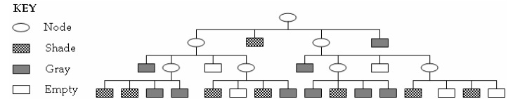
a) i) Identify how the quadtree works with raster data (2 Marks)
ii) Use the quadtree structure below to generate a spatial image
(8Marks)
b) When modeling spatial entities, a GIS designer must simplify the complexities of the real world into
basic two dimensional entity types
i) With examples, describe four of these entity types (4 Marks)
ii) Discuss three problems that may arise during this simplification (6 Marks)
Question Five (20 Marks)
a) Identify the strengths of remote sensing technologies (6 Marks)
b) i) Highlight the difference between the digital terrain model and the elevation
model (2 Marks)
iii) Define the concept of ‘the 4th dimension’ in GIS and describe four events that
can be modeled using this dimension (6 Marks)
c) Discuss how the internet assists in the implementation of GIS (6 Marks)