
 UNIVERSITY EXAMINATIONS: 2012/2013
SECOND YEAR EXAMINATION FOR THE BACHELOR OF
SCIENCE IN INFORMATION TECHNOLOGY
BIT2307 GEOGRAPHIC INFORMATION SYSTEMS
DATE: DECEMBER, 2012 TIME: 2 HOURS
INSTRUCTIONS: Answer Question ONE and any other TWO
QUESTION ONE
a) Distinguish between the following concepts;
i. Georeferencing and reclassification (2 Marks)
ii. Vectorization and rasterization (2 Marks)
b) i. Identify four sources of raster data (4 Marks)
ii. Highlight two strengths of the raster data model (2 Marks)
c) Describe three basic spatial entities as represented using the vector model
(6 Marks)
d) i. Define the term ‘plug-in’ and identify two types of plug-ins used in QGIS
(3 Marks)
ii. Discuss the process of creating a map (6 Marks)
e) Differentiate between the functional and the component definition of GIS
(5 Marks)
QUESTION TWO
a) Define the following concepts as used in GIS data analysis;
i. Spatial analysis (2 Marks)
ii. Aspatial query (2 Marks)
iii. Buffering (2 Marks)
b) List three events that trigger a refresh of the map canvas in QIS (3 Marks)
c) Using your practical knowledge, describe the procedure for accomplishing the
following tasks;
i. Changing the projection of a GIS project (3 Marks)
ii. Geo-referencing an entity (4 Marks)
iii. Digitizing a map (4 Marks)
QUESTION THREE
a) Discuss two approaches to 3D modeling in GIS (4 Marks)
b) Identify any four functions of a GIS application (4 Marks)
c) Describe the logical steps necessary to put a GIS to work using a diagram.
(4 Marks)
d) Many GIS software applications are in existence today, both commercially and in
open source. List the various types of these applications (2 Marks)
e) Give the meaning of the following terms
i. TIN (2 Marks)
ii. DEM (2 Marks)
iii. UTM (2 Marks)
QUESTION FOUR
a) There are a number of ways that 2D data can be structured in a computer. Among
these techniques are: Topological data structure, Whole polygon structure, point
and polygon structure and spaghetti structure. The figure below shows a
representation made up of 3 polygon structures (A, B, and C), 15 linear
structures (l1, l2 , l3, .. l15 ) , and nodes (a, b, c ..n).
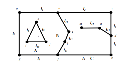
Describe the above representation using topological data structure. Use detailed
tables for your answer. (10 Marks)
b) i. Define the term ‘spatial referencing’ (2 Marks)
ii. Discuss the problems that can be experienced with spatial referencing
systems (8 Marks)
QUESTION FIVE
a) With examples discuss the main features that characterize topology (6 Marks)
b) Discuss the benefits of using a database for GIS attribute data management
(3 Marks)
c) The following table shows records of tenants to leased land parcels. Study it and
then attempt the questions that follow;
LEASE
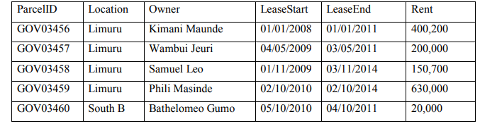
Write SQL statements to retrieve the following records;
i. The parcel numbers and owner names of all leased parcels (3 Marks)
ii. The records whose lease(s) has expired (2 Marks)
iii. All lease information with a rent higher than 200,000 (3 Marks)
iv. The parcel numbers, owner names and rent of parcels in Limuru (3 Marks)