
 UNIVERSITY EXAMINATIONS: 2011/2012
YEAR II EXAMINATION FOR THE BACHELOR OF SCIENCE IN
INFORMATION TECHNOLOGY
BIT 2307 GEOGRAPHIC INFORMATION SYSTEMS
DATE: APRIL 2012 TIME: 2 HOURS
INSTRUCTIONS: Answer Question One and Any other Two Questions
QUESTION ONE
a) Distinguish between the following concepts;
i. Satellite image and aerial photo (2Marks)
ii. Vectorization and rasterization (2Marks)
b) i. Discuss the advantages of using raster data in GIS (3Marks)
ii. Identify the ways in which raster data can be collected (4Marks)
iii. Highlight two aspects that would guide a geographer to use vector or raster data (2Marks)
c) Describe three basic spatial entities as represented using the vector model (6Marks)
d) Define the following concepts as used in GIS data analysis;
i. Network analysis (2Marks)
ii. Aspatial query (2Marks)
iii. Buffering (2Marks)
e) Highlight the major components of the GIS environment (5Marks)
QUESTION TWO
a) i. Define the term ‘plug-in’ and identify any two plug-ins used in QGIS (3Marks)
ii. Maps are a major source of data for GIS. Discuss the process of creating a map (6Marks)
b) Using your practical knowledge, describe the procedure for accomplishing the following
tasks;
i. Changing the background and border color of entities in a vector layer (3Marks)
ii. Geo-referencing an entity (4Marks)
iii. Outputting data sets stored in layers in the form of a map (4Marks)
QUESTION THREE
a)Define the term ‘projection’ and list any four projections available in QGIS (4Marks)
b)The following is a raster data structure that employs run-length encoding as a compaction
technique. Study it and answer the questions that follow;
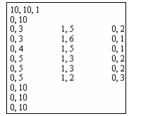
i. State the meaning of the first line (10, 10, 1) (2Marks)
ii. State the meaning of the figures (0, 10) that occur four times within this structure
(2Marks)
iii. Use the data structure to construct the corresponding raster image (4Marks)
iv. Apply an appropriate chain coding technique to the image your have created in (iii) above
(4Marks)
c)Highlight any four models for the third dimension (4Marks)
QUESTION FOUR
a)Explain the three modes or dimensions that characterize all GIS data (6Marks)
b)Remote sensing data is considered advantageous for many GIS applications. Discuss the
three major technologies for remote sensing (6Marks)
c)Discuss the problems that can be experienced with spatial referencing systems (8Marks)
QUESTION FIVE
a)With examples distinguish between the following features that characterize topology;
i. Containment (2Marks)
ii. Connectivity (2Marks)
iii. Adjacency (2Marks)
b) i. Identify the methods used to identify errors in the input of attribute data in GIS (3Marks)
ii. Discuss the benefits of using a database for GIS attribute data management (3Marks)
Due to the dynamic nature of all GIS data, there is need for 4th (time) dimension modeling.
Discuss any four types of events that can be used to model the fourth dimension (8Marks)