

Questions and Answers
Kenya Certificate of Secondary Education
2020 Geography Paper 1
Section A
Answer all the questions in this section.
1.(a) Define the term environment.(2 marks)
It’s a place, site, situation, surrounding, setting, or domain with conditions that influence the behaviour of any organism.
(b) Name two divisions of physical Geography.(2 marks)
- Geomorphology
- Climatology
- Meteorology
- Pedology
- Geology
- Hydrology
- Oceanograph2.(a) Give three characteristics of comets.(3 marks)
- They orbit around the sun
- They have a nucleus within the head
- They have a head surrounding the nucleus
- It has a tail always pointing away from the sun
- It sublimes as it nears the sun due to suns heat
- Carbon dioxide, water ices silicates, and fine dust are its main components
- Check if the student captured traits while in motion or stationary (b) State three proofs that show the shape of the earth is spherical(3 marks)
- During lunar eclipse the shape of the shadow of the earth casted on the moon surface is spherical in shape
- At the coast the approaching vessels the topmost part of vessels will appear first before the whole body of the vessel is seen, if the earth was flat the whole vessel will be seen wholly once
- Photographs taken by space satellites shows the earth to be spherical in shape
- On any high tower on the earth surface, the horizon of the earth appears curved
- A plane set flying fast in a straight line will eventually find if self where it started without flying back this will never happen if the earth was flat
- All other planets are spherical in shape the earth being one of them it must also be spherical
- The rising and setting of the sun is a strong evidence that our earth is spherical3.(a) Give two types of igneous rocks.(2 marks)
- Extrusive
- Intrusive(b) Identify three uses of rocks.(3 marks)
- Pumice is used for bathing
- Marble is used for house decorations
- Coal is use heating in industrial processes
- Basalts is mixed with tar for tarmacking roads
- Obsidian granite rocks are used for sculpturing
- Limestone rocks are raw materials for production of cement
- Hard rough rocks like diorite are used for sharpening knifes4. The table below shows the rainfall and temperature data for town Y. Use it to answer
Month J F M A M J J A S O N D Temperature (ºC) 21 21 20 18 15 14 13 13 15 16 18 20 Rainfall (mm) 24 25 30 74 17 143 131 126 70 55 31 27 (a)(i) What is the mean annual range of temperature?(1 mark)
21°c-13°c = 8°c
(ii) Calculate the rainfall totals for town Y.(1 mark)
24+25+30+74+17+143+131+126+70+55+31+27 = 753 mm of rainfall
(b) State three climatic conditions experienced in the hot deserts.(3 marks)
- Low rainfall/ below 250mm a year
- High temperatures through out the year/ over 35°C
- The diurnal range of temperatures is very large/ hot days and cool nights
- Low humidity/ below 45%
- Skies are cloudless/ clear
- There are strong dusty winds/ sand storms/ dry winds5.(a) Differentiate between ocean and sea.(2 marks)An ocean is a large/ extensive body of saline water occupying a basin between continents, while a sea is a large body of saline water along the continental margins
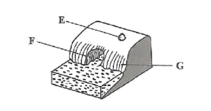
(b) The diagram below shows some coastal features. Name the features marked E, F, and G. (3 marks)
E- blowhole/ gloup
F – Cave
G – Cliff
Answer question 6 and any other two questions from this section.
6. Study the map of Kijabe 1:50,000 provided and answer the following questions.
- (a)(i) Convert the scale of the map extract into a statement scale.( 2 marks)1cm rep 50 0005 000 cm = 50 000/100000 = 0.5 KM
(ii) What is the bearing of the pump house at grid square 3893 from the trigonometrical station at Mweri?( 2 marks)
300o±1, N60oW±1
(iii) Calculate the area of the part of the forest to the east of easting 40 and south of northing 97. Give your answer in square kilometres.(2 marks)
full squares = 15
½ squares =20 →20/2=10
= 15 + 10= 25
=25 ± 1
(b)(i) Apart from forest, give three types of natural vegetation found in the area covered by the map.(3 marks)
- Thicket
- Woodland
- Scrub
- Bamboo
- Scattered trees(ii) Identify the three river drainage patterns found in the area covered by the map.(3 marks)
- Radial drainage pattern
- Dendritic drainage pattern
- Parallel drainage pattern(c)(i) Using a vertical scale of 1 cm to represent 100 metres, draw a cross section from the water tank on grid square 2592 to the peak of Kijabe hill on grid square 2699. (4 marks)
- (ii) Calculate the vertical exaggeration of the cross section.(2 marks)VS = = 1:100m = 1: 10 000 = 1 x 5HS 1:50 000cm 1: 50 000
5 times
(d) Citing evidence from the map, identify two economic activities in the area covered by the map.(4 marks)
Economic activity Evidence – Transportation – Roads/ railway/motorable track – Forestry – Forest/ forest station – Trade – Shops – Communication – Post office – Quarrying – Murram pit quarry – Lumbering – Saw mills – Cattle rearing/keeping – Cattle dip – Dairy farming – Dairy – Manufacturing/ procesing – Kagwe carbacid plant – Crop farming – Plantation 7.(a)(i) Define the term vulcanicity (2 marks)Vulcanicity is the process through which liquid , solid or gaseous material are formed into the earth crust or on to the surface due to high pressure and temperature.
(ii) Name the three stages in the life cycle of a volcano.(3 marks)
Active
Dormant
Extinct
(b)(i) Lava plateau(4 marks)
- It is formed when magma reaches the earth surface through multiple vents/ fissures
- The lava is ultra-basic/ extremely fluid it flows over long distances, spreading evenly, covering hills and depressions
- The lava cools slowly and solidifies
- Successive eruptions build up more layers, building a thick plain land/ table land called lava plateau(ii) Geyser(4 marks)
- Water percolates underground through cracks in the rock
- Water gets into contact with hot igneous rocks the water is superheated to form gases/ steam pressure builds up
- Pressure forces the steam and water to be ejected to the surface
- The water and steam is emitted intermittently as pressure level changes to form a geyser>p> (iii) Caldera(4 marks)
- Lava pours out of a central vent to form volcanic cone
- Vent is sealed when lava solidifies
- Solidifies lava blocks gases and steam beneath, preventing them from escaping
- Pressure piles up below, leading to a violent eruption which blows off the top of the cone forming depression. ( must be mentioned to secure maximum marks)
- The depression is large and circular and it is known as caldera OR
- Lava pours out of central vent to form volcanic cone
- Magma chambers are left empty/void
- Due to overlying weight at top of cone, pressure is exerted
- Top of the cone subsides forming a depression ( this part must be mentioned to secure maximum marks)
- This depression is large and circular and is called a caldera OR (outward collapsing theory)
- A volcano is build of ash and pyroclasts to form a dome
- Weak materials at the base are unable to support the overlying materials / weight
- Materials at thee base spread outward as top part subsides,(must mention to secure full marks) leading to large depression known as caldera.(c) Explain four positive ways in which volcanic features influence human activities.(8 marks)
- Volcanic lava upon weathering forms fertile soils which are used in agricultural activity
- Some volcanic plugs/aureola, have valuable minerals which can be mined
- Steam jets are used in harnessing geothermal electricity for domestic /industrial use
- Some volcanic features attracts tourists earning a country foreign exchange
- Volcanic mountains influence the formation of relief rainfall on their slopes which encourage agricultural activities/settlement.
- Volcanic lakes used for fishing which is a source of income/ food
- Some lakes are a source of water for domestic/ industrial use
- Volcanic mountains are source of rivers which provide water for domestic/ industrial irrigation.
- Hotsprings/ spurs are used for medicinal purposes
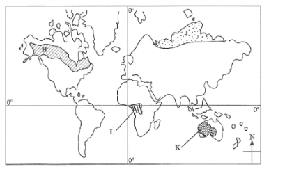
- Some volcanic rocks are used as building materials8. The map below shows some vegetation regions of the world. Use it to answer question a (i) and a (ii). (a)(i) Name the vegetation marked H, J and K.(3 marks)H – Coniferous forest
J – tundra
K – Tropical desert
(ii) Describe the characteristics of the vegetation found in the area shaded and marked L.
Trees grow close to each other/ closely packed Trees form canopies/ 3 distinct layers Trees have straight smooth trunks Most tree species are hardwood The forest trees are evergreen Trees have broad leaves/ drip-tipped leaves Forests have little/ no undergrowth Forests consists of a variety of tree species Some trees have buttress roots The trees are tall The forest have climbers/ epiphytes Trees take long to mature
(6 marks)
(b) Explain how each of the following factors influence distribution of vegetation: (i) Rainfall(2 marks)
(ii) Soils.(2 marks)
(c) State five uses of Savanna vegetation.(5 marks)
(d) You intend to carry out a field study on vegetation within the local environment. (i) State three objectives you would formulate for the study.(3 marks)
(ii) Give four reasons why it is important to have a work schedule.(4 marks)
9.(a)(i) Apart from biological weathering, list two other types of weathering. (2 marks)
Rainfall
Areas receiving high rainfall encourage growth of many varieties of tree species/ luxuriant vegetation Areas receiving low rainfall have few species/ scanty vegetation Areas with low rainfall have stunted vegetation
(ii) Explain ways in which plants cause weathering of rocks.(6 marks)
Soils
Deep well drained soils support growth of dense vegetation In fertile/ shallow/ thin soils support scanty vegetation
(b) Explain how each of the following physical factors influence mass wasting:
(i) Earth movement(2 marks)
(ii) Nature of rock materials.(2 marks)
(c) Describe each of the following processes of mass wasting:
(i) Avalanche(2 marks)
The grassland area is used for livestock farming/ grazing The vegetation provides habitat for wild animals Trees are used for bee keeping Some of the vegetation is used for medicinal purposes Some of the vegetation provides wild fruit Trees are a source of wood fuel Some vegetation provides building material Grass forage decompose to farm humus
(ii) Rock fall.(3 marks)
(d) Describe each of the following types of mass wasting: (i) Earth flow (4 marks)
To identify vegetation species dominant in the area.
To find out how the local people benefit from the vegetation.
To investigate problems facing vegetation in the area.
To find out methods used to conserve vegetation in the area.
(ii) Slump.(4 marks)
It helps carry out the filed activities systematically.
It helps in estimating the total time required for the study.
It ensures all areas of study are adequately covered.
It helps in assessing progress of the study.
It enables for proper use of available time.
It confines one to the scope of the study.
10.(a)(i) Give three features found in the upper stage of a river.(3 marks)
- V-shaped valleys
- Potholes/ plunge pools
- Interlocking spurs
- Waterfall/rapids/cataracts
- Gorges/ canyons
- Winding channels(ii) State four factors that favour the formation of braided channels.(4 marks)
- River must be carrying a large load
- Should be reduction of stream gradient
- Should be presence of obstacles
- Should be reduction of volume of water in the river
- River flows at low velocity
- Widening of river channel(b) Explain the processes by which a river transports its load.(8 marks)Light insoluble materials such as silt and sand are carried in suspension and maintained within the turbulence of the water. Some of them float on surface of the water Large particles/ boulders are pushed and rolled along river bed by force of gravity and moving water Soluble material are dissolved in the water and carried down stream in form of solution Some particles/ pebbles which are fairly heavy are moved in a series of leaps, hops and jumps along river bed through process known as saltation.
(c) With the aid of well labelled diagrams, describe how a river capture occurs.(7 marks)
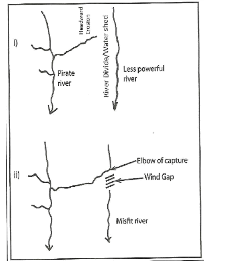
- River capture may only occur where there are 2 adjacent rivers/ share a watershed One river has more erosive power than the other The more powerful river erodes vertically faster than weaker one thus flows at lower level than than the other. The more power river erodes it’s valley towards the other river’s valley through head-ward erosion. Eventually, the powerful river joins valley of weaker river The powerful river diverts the head waters of the weaker river into it’s channel The diversion of the headwaters is called river capture.(d) State three negative effects of rivers to human environment.(3 marks)
- Some rivers with almost stagnant water harbor waterborne diseases
- Rivers flooding during rainy season may cause destruction of property and loss of life
- Some rivers are habitats to dangerous animals which may attack humans/ destroy crops
- Some rivers are unnavigable hindering transportation
- River flooding also causes displacement of people