
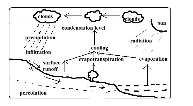
Endless interchange of water between the sea, atmosphere and land.
Processes in Which Circulation Is Carried Out
1. Evaporation
- Changing of water into water into water vapour when it‟s heated by solar radiation.
- Evapotranspiration: Combined loss of water from the soil through direct evaporation and transpiration by plants.
2. Cooling
Reduction of water vapour temperature as it rises into the atmosphere when it expands due to reduced temperature and pressure.
3. Condensation
Turning of water vapour into tiny water droplets which form clouds when cooling continues below dew point.
4. Precipitation
The process in which the earth receives moisture from the atmosphere.
It occurs when droplets formed by condensation combine forming heavier drops which fall on the ground as rain or may become frozen to form snow, hail, sleet, etc.
5. Surface runoff
Some of the water from precipitation that flows on the surface into valleys, ponds, lakes, etc.
6. Infiltration
Entry of water into the ground through pores, joints and cracks in rocks.
7. Percolation
Downwards and sideways movement of water that has entered into the ground.
8. Overland flow
Surface runoff makes the overland flow.
River water flows back to the oceans where evaporation takes place again and water cycle is repeated.
Significance of Hydrolological Cycle
Positive
- Provides water to man from precipitation and underground water.
- Provides rain to man who is useful in agriculture.
- Atmospheric water is important in regulating heat loss from the earth by absorbing terrestrial radiation and reflecting it back to the earth keeping the lower atmosphere warm.
Negative
- May lead to shortage of water when evaporation rate exceeds precipitation.
- May lead to decreased agricultural production as a result of excessive evaporation causing weathering of crops.
- May lead to flooding when excessive evaporation cause increased rainfall.
- May lead to shortage of rainfall if there is less evaporation due to low temperature.
ACTION OF RIVERS
A river is a mass of water flowing over the land in a definite channel.
Work of a River
- Drain excess water from the land.
- Sculpturing land through erosion, transportation and transportation.
River Erosion
- Removal by river water of materials from the sides and bed of the river channel.
Factors Influencing River Erosion
1. River volume
- A river with a large volume has a greater kinetic energy to erode than one with a small volume.
2. Slope of land
A river flowing on a steep channel has greater velocity and therefore more energy to erode its channel than one flowing over gentle or flat land.
3. Rivers load
- A river with large, rough and heavy load e.g. tree trunks and boulders erodes more than one with light, fine and smooth materials e.g. sand.
- A river carrying more load erodes more than one with less load as it has more abrasive tools.
4. Nature of bed rock
- Erosion is faster where a river flows over soft bed rock and less where it flows over hard rock.
Processes/Ways of river erosion
1. Solution/Corrosion – River water dissolving soluble minerals and carrying them away.
2. Hydraulic Action
- Erosion by the force of river water when it thrusts itself into cracks and joints of rocks on the sides of the channel dislodging lumps.
- Also by pushing air into the cracks, compressing it increasing pressure which widens the cracks eventually dislodging lumps.
3. Abrasion/Corrasion
- Abrasion is scratching of the bed and banks by materials are carried away by the river.
- Corrosion is hurling of rock fragments carried by the river against rocks which weaken and eventually break them.
4. Attrition
- Hitting against one another of rock fragments carried by river water breaking one another into smaller pieces.
Types of River Erosion
- Vertical Erosion
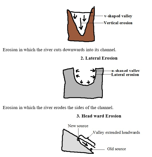
- Erosion in which a river cuts back at its source.
Where there is a water fall.
- The river undercuts at the base of a waterfall.
- The rock above the undercut cliff collapses.
- The position of waterfall shifts upstream.
Where gulleying or soil creep occurs where there is a spring causing its position to shift upstream (spring sapping).
Resultant Features of River Erosion
- Stream Cut Valleys
Valleys with V, open V or U shaped cross sections along the river channel.
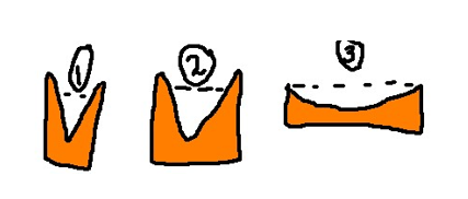
In the source region a river cuts itself a channel which starts as a gulley.
- The channel is deepened by vertical erosion resulting into a v-shaped valley. oIn the middle stage lateral erosion widens and deepens the valley resulting in a more open v-cross section.
- In the old stage lateral erosion creates a very wide channel with a U-shaped cross section. Gorges – Narrow, deep, steep-sided valley.
Ways/modes of formation
- Where a river flows along a fault or a section of soft rocks eroding the channel vertically through the soft rocks or fault.
- By headward erosion at a water fall when the river‟s erosive activity is increased due to increased gradient causing the river to undercut at the base of the water fall, then the rock above the undercut base collapses causing the waterfall to shift upstream resulting in a gorge below the water fall.
- Where a river flows across a plateau with alternating horizontal layers of hard and soft rocks eroding them resulting in a gorge with stepped sides called a canyon e.g. Grand canyon on R. Colorado in USA.
- Due to river rejuvenation when the river‟s erosive activity is renewed causing the river to vigorously erode deep into its channel.
- Where a river maintains its course across land which is being uplifted gradually.
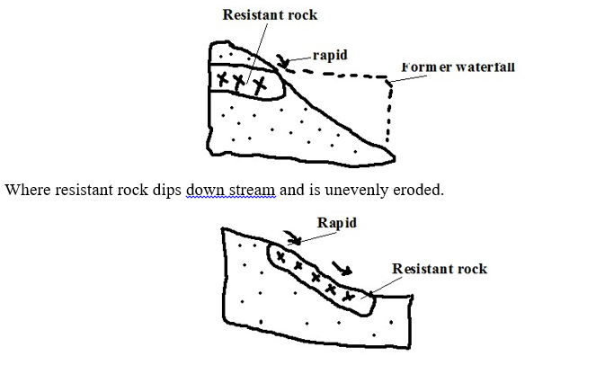
Rapids
A section of the rivers course where the bed is suddenly steepened causing the water to suddenly flow swiftly.
How they are formed
- Where a less hard rock lies below a soft rock and the soft rock is eroded more resulting in a steep slope.
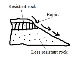
2. Where a water fall has been eroded by headward erosion reducing its height.
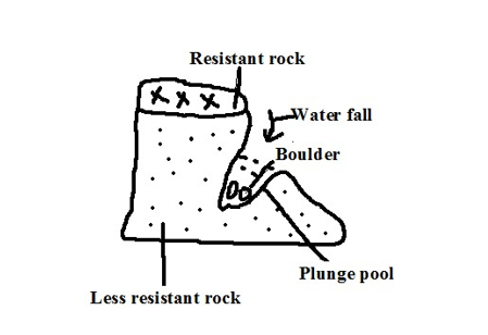
Water Falls
A place on a rivers course where a river bed is vertical or nearly vertical.
Formation
- Where a river descends over a sharp edge of a plateau encountering a sharp drop.
- Where a river descends a cliff into the sea.
- Where a river descends a fault scarp.
- Where a river descends a sharp edge of a plateau.
- Where a river is blocked by lava flow causing water to accumulate on the upstream side and a water fall forms at the point of overflow.
- Where a resistant rock lies across a river with a less resistant one on the downstream side and the less resistant one is eroded faster causing a rapid to be first formed, then a waterfall.
Circular depressions on a river bed.
- Form where a river flows over shallow depression and develops strong circulating currents which cause the load to scratch the bed in circular motion.
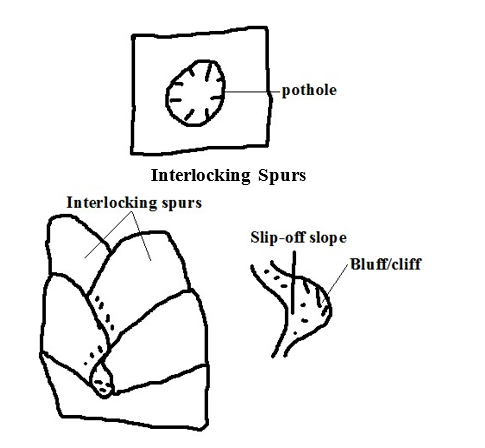
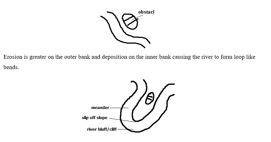
- Highland projections which appear as they fit together.
Formation
- Where In the youthful stage, a river flows around spurs undercutting the outer bank more than the inner bank causing the bends to be more pronounced making the spurs to appear as if to fit together. The outer bank becomes river cliff/bluff and the inner bank slip off slope.
River Transportation
- River carrying away materials that its water has eroded from the channel.
Factors Influencing River Transportation
1. Rivers Volume
A river with large volume of water has more energy and therefore greater carrying ability than one with a small volume.
2. Gradient
A river flowing on a steep channel has greater ability to transport than one on a gentle slope because it flows fast due to gravity.
3. Rivers Load
- Small and light particles are transported over long distances while heavy materials are transported for a short distance.
- Dissolved load is carried all the way to the rivers mouth.
- Small amount of load is transported for a long distance while large amounts of load collide reducing the speed and therefore rivers ability to transport causing some of the load to be dropped along the way.
Processes/ways of River Transportation
1. Suspension
- River transportation of light and insoluble materials in form of a mixture.
2. Saltation/Hydraulic Lift – River transportation of large particles through a series of jumps and hops. oMaterials are lifted by force of moving water and pushed for a short distance and land back on the river bed by gravity. The process is repeated causing the load to be transported downstream.
3. Traction
- River transportation of heavy materials like boulders by rolling them by the force of water.
4. Solution – River transportation of load in solution form.
Load transported by suspension, Saltation and traction is called clastic load while that by solution is called dissolved load.
Deposition
- Laying down of some of the load carried by the river when energy decreases.
Factors Influencing Deposition
1. Gradient
When gradient reduces the river‟s speed decreases and hence its energy is reduced causing it to drop some of the heavy load.
2. Rivers Volume
When rivers volume decreases its energy also decreases causing it to deposit heaviest load then lighter ones.
3. Obstacles
Obstacles such as swamp vegetation and rock outcrop reduce the river‟s speed and also trap some of the load thereby facilitating deposition.
4. River Bed Width and Depth
Where a rivers channel becomes wide and shallow there is less water per unit area and hence the river has lower capacity to transport so deposition of excess load begins.
Resultant Features of River Deposition
1. Alluvial Fans and Bajadas
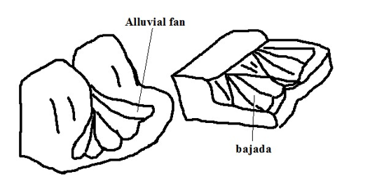
- Fan shaped deposits of alluvium.
Formation
- The river flowing through a narrow channel enters a plain from a higher ground and suddenly spreads out. oThere is a sudden loss of velocity causing the river to scatter alluvium all around to form an alluvial fan.
- Alluvial fans merge to form a continuous feature called bajada or piedmont fan.
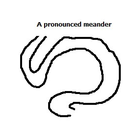
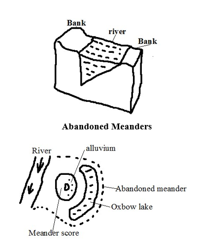
2. Meanders and Oxbow Lakes
Meanders are loop-like bends in a rivers course.
Oxbow lake is a horse shoe shaped section of a former river.
Formation
- In mature stage river flows sluggishly due to reduced gradient.
- It meets an obstacle and flows around it.
Erosion continues on the outer bank (bluff) narrowing the land between the two outer banks forming a pronounced meander e.g. on rivers Yala, Nzoia and Tana.
During the floods when the river has more energy it cuts across the narrow land.
The former bends are cut off by deposition to form an oxbow lake e.g. Kanyaboli on R.Yala and Shakababo on R.Tana.
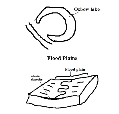
Wide gently sloping plain of alluvium on the floor of a river valley.
Formation
- A river meanders.
- There is erosion on outer bank and deposition on the inner bank.
- The process continues and layers of alluvium deposited on inner bank join to form a plain e.g. Nzoia and Yala flood plains.
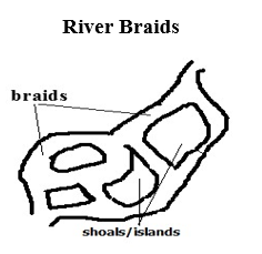
Net work of diverging and converging channels along a rivers course.
Factors favouring formation of braids
- River must be carrying large load.
- Reduced gradient on the section.
- Reduced amount of water such as in dry season or arid conditions.
- Presence of obstacles such as rock out crops.
Formation
- River flows sluggishly due to low gradient.
- Deposits of alluvium are laid on river bed.
- The deposits raise the river bed causing the channel to be subdivided into channels or distributaries.
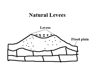
Raised river banks which are made of alluvial materials.
Formation
- River floods and spills over its banks. o Deposition of coarse materials near the banks and fine materials are carried further on the flood plain.
- Coarse materials accumulate raising the banks above the general level of the flood plain.
Effects of Levee Formation
- Creation of differed tributaries and confluences.
Differed tributary: Tributary blocked from joining the main river by levees.
Differed confluence: New point where the differed tributary joins the main river downstream. b) Destructive flooding.
- Due to the river bursting its banks during the flood season due to the bed being raised above the general level of the flood plain.
- Due to differed tributaries flowing into the flood plains.
- Because the river channel has become narrower and shallower due to deposited alluvium.
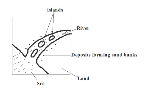
Estuaries
- Broad channel at the mouth of a river where the river enters the ocean as a whole.
- Some are deep and narrow because sediments are carried away by ocean currents while others are wide and shallow due to sediments covered by water e.g. on R. Congo and Gabon.
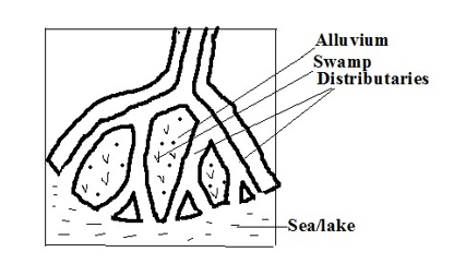
Deltas – Low lying tract of alluvial deposits formed at the rivers mouth.
Ideal Conditions for Formation of A Delta At A Rivers Mouth
- Large load such as from a large catchment area where erosion is taking place actively.
- The rivers course to be free from obstacles such as swamps so as not to filter sediments before they reach the mouth.
- Low speed at the point where the river is entering a sea or lake for deposition to take place.
- The rate of deposition should be higher than the rate of erosion by sea or lake currents.
How a Delta Forms
- The speed of the river is checked by sea or lake.
- Heavy load is first deposited.
- Lighter load is carried further into the sea causing that part of the sea to become shallower.
- The part is colonised by plants making it swampy but firmer.
- Plants trap more alluvium making the delta to grow in height.
- The river builds levees making it narrower.
- The river burst its banks and small channels branch off the main river and carries water into the sea or lake (distributaries).
Types of Deltas
- Marine: Type formed at sea.
- Lacustrine: at a lake.
- Inland Delta: Deltas which form along a rivers course before it reaches the lake or sea.
Formation
- The velocity of the river is checked on entering a relatively flat swampy land.
- The river builds up levees.
- The river bursts banks forming distributaries.
- Alluvial deposits are spread over vast areas when river floods e.g. Niger and Okavango deltas.
Arcuate Delta
- A delta with a convex shoreline on the seaward end due to strong currents spreading materials over a wide area on seaward side.
- Has many distributaries e.g. Tana and Rufiji deltas.
Birds Foot Delta
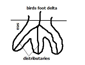
- Type of a delta with a pattern resembling the foot of a bird.
- Has few distributaries.
- Formed on a river carrying large quantities of fine alluvium into water where there is low wave energy e.g. Omo and Mississippi deltas.
Estuarine Delta
Delta which has formed on an estuary.
Formation
- The rivers load is deposited on the estuary when the speed is checked by sea.
- The river cuts across in a single channel that may be bordered by levees e.g. on R.Volta in Ghana and on R. Zambezi.
Development of a River Profile – Longitudinal section of a river from source to mouth.
Youthful/ Torrent Stage Characteristics
- Steep gradient.
- The river flows very fast.
- Vertical erosion is dominant
- Headward erosion is evident.
Features
- V- shaped valleys
- Waterfalls
- Rapids
- Potholes
- Gorges
- Interlocking spurs.
Mature/ Valley Stage Characteristics
- Low and almost regular gradient.
- The flow is less swift.
- The river is wider due to being joined by tributaries.
- Lateral and vertical erosion but lateral is more active.
- Deposition starts at some sections.
Features
- Wider open v-shaped valley
- Meanders
- River bluffs/cliffs
- Slip off slopes
Old/ Plain Stage
Characteristics
- Very gentle/almost level gradient.
- Very slow flow of river.
- The main work of the river is deposition.
- Some lateral erosion occurs.
- Seasonal floods are common.
Features
- Shallow broad flat bottomed u-shaped valley.
- Meanders
- Oxbow lakes
- Natural levees
- Differed tributaries
- Differed confluences
- Braided channels
- Flood plains
- Deltas
- Distributaries
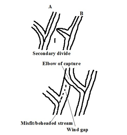
River Capture/Beheading/Piracy/Abstraction
Diversion of head waters of one river into the system of an adjacent powerful river due to erosion.
The river that captures is called pirate.
The captured one is called victim.
How it occurs
- At first there are a powerful river and a weaker river flowing adjacent to each other.
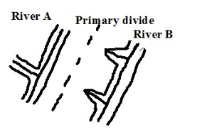
The powerful river erodes vertically and laterally than the weak river making it to flow at a lower level. oAt the same time, it extends its valley backwards by headward erosion.
- The stronger river eventually joins the valley of the weak river.
- The headwaters of the weaker river start flowing into the valley of the stronger river e.g. R. Tano in Ghana was captured by the Black Volta River and R. Eyong was captured by Imo in S. Nigeria.
The remaining section of the beheaded river is called a misfit/beheaded river.
The dry valley between the elbow of capture and the new course of the misfit stream is called a wind gap.
River Rejuvenation
Renewal of erosive activity of a river.
Happens in the old stage.
Causes A. Change in the Base Level
Base level is the lowest level to which a river can erode its bed.
Rejuvenation resulting is called dynamic rejuvenation
- Drop in sea level o The river mouth moves further seawards. o A steep gradient occurs between the old and the new mouths causing the river to starts to move swiftly. o Vertical erosion resumes extending back to the flood plain.
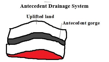
- Uplift of a section of land along the rivers course.
- Faulting or folding may occur. o A section of land along a rivers course is uplifted. o The gradient is increased causing the river to flow swiftly and undercut through the uplifted section.
- An antecedent gorge is formed.
- Unequal sinking of land along a rivers course.
- The downstream side sinks more than the upstream one.
- An increase ingredient occurs causing the river to flow swiftly
- The river starts to undercut more vigorously than before.
4. Increase in Rivers Discharge
Rejuvenation resulting is called static rejuvenation
- The rivers discharge increases due to high precipitation or capture.
- The rate of erosion becomes higher due to increased discharge.
- The river starts to undercut more vigorously.
5. Change in Rock Structure
- A river passes a resistant rock and starts flowing over a less resistant rock.
- The river starts eroding more vigorously into the softer rocks.
Features of River Rejuvenation
- Knick Points
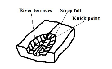
- A sudden break of slope in a rivers profile as a result of change in sea level.
- River Terraces
- Step like features formed when a river rejuvenates and cuts a new valley through the flood plain causing a plat form will form where the floor of the former flood plain was.
Water Falls
Are formed when knick points are deepened e.g. Charlotte falls in Sierra Leone.
- Antecedent Gorges
- Gorges which form where a river undercuts though a section of land that is being uplifted e.g. Turkwel gorge.
- Incised Meanders
- Meanders that have been cut deeper into by a rejuvenated river.
Types
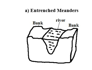
- Formed from vertical erosion causing both valleys to be steep and symmetrical.
Ingrown Meanders
- Formed by lateral and vertical erosion causing one valley side to be steeper than the other and hence asymmetrical in cross section.
- Meanders abandoned during formation of oxbow lakes when the river takes a short-cut leaving an enclosed portion of land surrounded by an oxbow lake.
Drainage Systems – Main river together with its tributaries.
Types
- Accordant Drainage System
- Drainage system in which a river flows according to slope and rock structure by following areas of weak lines.
- Discordant Drainage System
- Drainage systems in which rivers don‟t flow in accordance with the slope, rock structure and land forming processes.
Types

- Drainage system where a river maintains its course while the surrounding land is being uplifted.
Superimposed Drainage System
- Drainage system which develops where a river maintains its flow over a new set of rocks after removing a former set of rocks.
Back Tilted/Reversed Drainage System
- Drainage system where direction of flow is reversed be due to capture, uplifting or down warping e.g. R. Kagera, Katonga and Kafu.
Significance of Rivers and Their Features Positive
- Rivers are sources of water for domestic and industrial use.
- Rivers water is used for irrigation.
- They provide port facilities where they have rias and estuaries.
- Some rivers are used for transportation e.g. R. Congo and Nile.
- Some rivers are fishing grounds e.g. Tana.
- Rivers are dammed and used for H.E.P generation.
- Features formed by river action such as waterfalls, gorges and oxbow lakes are a tourist attraction.
Negative
- Rivers flood causing loss of life and property.
- Rivers may lead to drowning accidents especially when they are flooded.
- River water can be a medium of spreading diseases such as bilhazia and malaria.
- Some wide rivers are barriers to transport and communication.
- Some rivers also harbour dangerous wild animals which can kill humans e.g. crocodiles, hippos and snakes.