
Meaning of Emerging trends in disaster management
More than 90 per cent of natural disaster related deaths are to be found in developing countries. Disaster impact statistics show the global trend – there are now more disasters but fewer people die in proportion, even though more population is affected and economic losses are increasing, as discussed in the next section.
Closely linked and influenced by changing perception, hazards and vulnerability is constantly shaped by dynamic and complex socio-economic and ecological processes. They are compounded by stresses felt within individual societies.
The current aspects of physical exposure of human beings and economic assets have been partly shaped by historical patterns of settlements. Beneficial climatic and soil conditions that have spurred economic activities are in many cases also associated to hazard-prone landscapes. Both volcanic slopes and flood plains areas have historically attracted human activities. Where settlement patterns have contributed to configure risk scenarios, new forces, such as population growth and increased rural/urban migration, act as dynamic pressures contributing to changing patterns in increasing people’s exposure to hazards.
The processes through which people and goods become more exposed to hazards are also socioeconomic conditioned. In particular, poverty levels and the impact of development processes, especially those associated with an increasingly globalised society, are reflecting, to some degree, current trends in socio-economic vulnerability to disasters. The pace of modern life has also introduced new forms of vulnerabilities related to technological developments. In addition to discouraging poverty levels, the emergence of virulent biological threats has revealed even greater vulnerability.
Systemic ecological and localized environmental degradation is becoming highly influential as well, lowering the natural resilience to disaster impact, delaying recovery time and generally weakening the resource base on which all human activity is ultimately dependent.
At the ecosystem level, phenomena like El Niño/La Niña, climate change and the potential for rising sea levels, are affecting the patterns and intensity of hydrometeorological hazards. Environmental degradation influences the effects of natural hazards, by exacerbating their impacts and limiting the natural absorptive capacity and resilience of the areas affected.
Biological hazards in the forms of plant or animal contagion, extensive infestations, human disease epidemics and pandemics, continue to factor into the disasters-development scenario in new and unpredictable ways. They exert considerable socio-economic impacts on food security and human mortality, health and economic productivity, among other things.
Disaster triggered by technological hazards often resulting from major accidents associated with industrialisation and forms of technological innovation, have significant socio-economic and environmental impact. Although technological hazards have been part of society for hundreds of years, the trends are showing an increasing impact. Technological advancements, specifically in the energy, transport and industrial sectors, are developing innovations with associated risks that are not always understood or heeded. The adverse effects of some technological disasters, both on society and on the environment, can considerably outlast the impacts associated with natural disasters.
Trends in disaster impact
While no country in the world is entirely safe, lack of capacity to limit the impact of hazards remains a major burden for developing countries, where more than 90 per cent of natural disaster related deaths are to be found.
Twenty-four of the 49 least developed countries (LDCs) still face high levels of disaster risk. At least six of them have been hit by between two and eight major disasters per year in the last 15 years, with long-term consequences for human development (UNDP, 2001). These figures do not include the consequences of the many smaller and unrecorded disasters that cause significant loss at the local community level.
The re-insurance giant Munich Re, a member of the ISDR Inter-agency Task Force, in its annual publication Topics for 2000, looked at the trend of economic losses and insurance costs over a 50 year period linked to what it calls “great natural catastrophes”.
There were 20 of these, costing the world US$ 38 billion (at 1998 values) between 1950 and 1959. However, between 1990 and 1999, there were 82 such major disasters and the economic losses had risen to a total of US$ 535 billion. That is, disasters had multiplied fourfold but economic losses were 14 times higher. And in each decade between, both the number of great disasters and the economic loss involved had risen steadily. However, losses in 2000 and 2001 were down.
These are absolute figures of economic loss, most of them to be found in developed and industrialized countries. But seen as losses by percentage of GDP, it is developing countries that lose most in relative terms, as shown in the graphic based on figures provided by MunichRe. For example, the economic losses of the United States from the 1997-98 El Niño event were estimated to US$ 1.96 billion or 0.03 per cent of GDP. The economic losses in Ecuador were US$ 2.9 billion, but this represented 14.6 per cent of GDP (ECLAC 2000).
The International Federation of Red Cross and Red Crescent Societies, another ISDR Task Force member, confirms the worsening trend of human suffering and economic loss during the last decade. The total number of people each year affected by natural disaster – that is, who at least for a time either lost their homes, their crops, their animals, their livelihoods, or their health, because of the disaster – almost doubled between 1990 and 1999, by an average of 188 million people per year. This is six times more than the average of 31 million people affected annually by conflict.
Comparing the last three decades, the trend shows an increase in the number of natural hazard events and of affected populations. Even though the number of disasters has more than tripled since the 1970s, the reported death toll has decreased to less than half (see grahpic page 12). This is among other factors due to improved early warning systems and increased preparedness. This statistic varies enormously depending on region and figures used. One needs to bear in mind that large disasters are rare events that defeat any statistical analysis in the short term. Perhaps more significant in the life of many are those daily disasters, generally underreported and not reflected at all in global figures on losses, but accumulating to probably large tolls of both economic and health losses
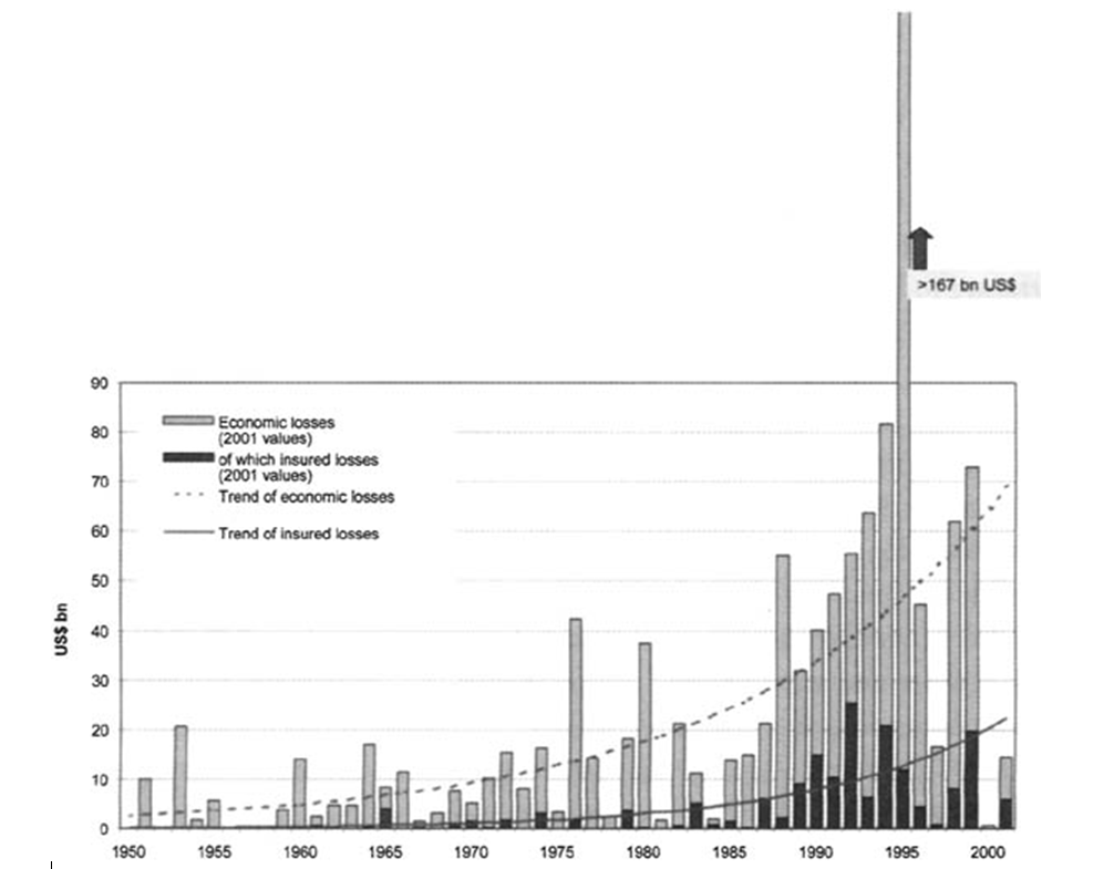
Economic Losses, great natural catastrophes 1950 – 2001
There is a considerable geographic variation in the occurrence and impact of natural hazards. Asia is disproportionately affected with approximately 43 per cent of all natural disasters in the last decade. During the same period, Asia accounted for almost 70 per cent of all lives lost due to natural hazards. During the two El Niño years of 1991-92 and 1997-98, floods in China alone affected over 200 million people in each year. Nevertheless, in relative terms and counted per capita, Africa is the most heavily affected country, in particular when drought, epidemics and famine are included.
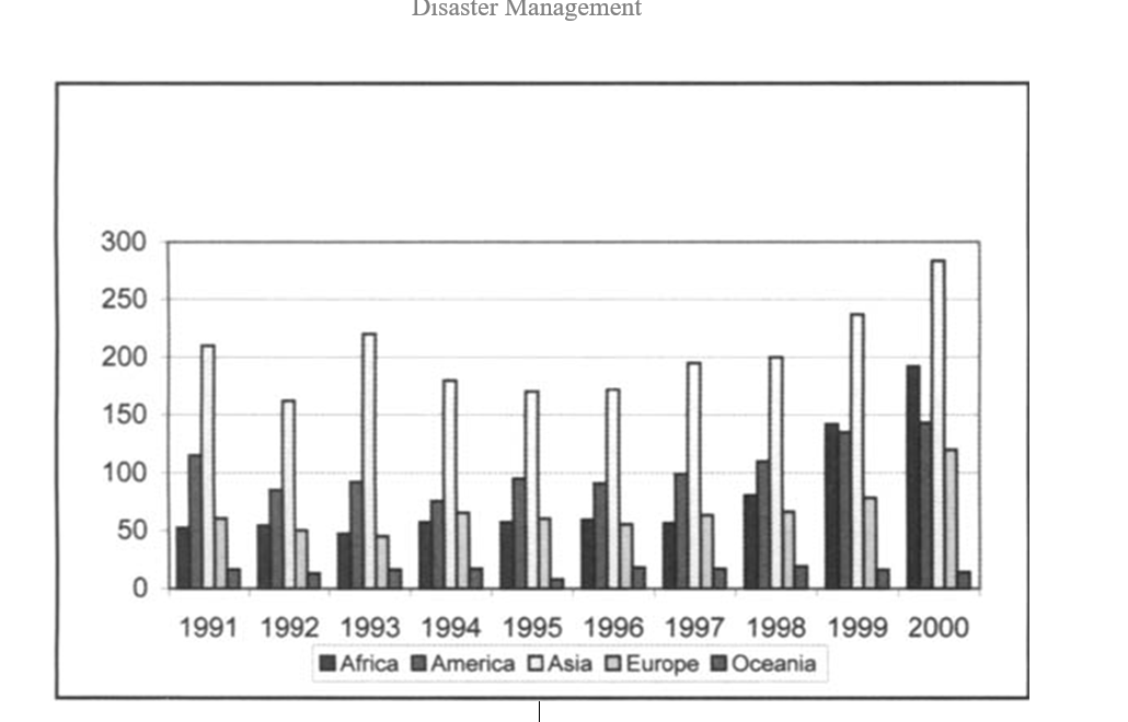
Total Number of Reported Disasters, (1991-2000)
The single most terrible year in human loss during the last decade was 1991, when a cyclone devastated Bangladesh killing 139,000 people, bringing the global total of deaths for that year to 200,000. Cyclones are cyclical events and they continue to hit the Bangladesh coasts but no such catastrophe has happened again. This is at least in part because the machinery of warning and preparedness – watchful officials, an aware public and a stronger sense of community responsibility – came into play.
The worst global economic loss during last decade occurred in 1995, due to the Great Hanshin-Awaji earthquake in Kobe, Japan. A highly developed, prepared and economically strong nation faced serious set backs economically by loosing important facilities of its primary port. Even seven years after that disaster, the amount of shipping trade in Kobe has dropped by 15 per cent. But now Kobe is rebuilt and modernised.
Trends in hazards
Until recently, the intensity and frequency of natural hazards, as events, whether geological or hydrometeorological in nature, only varied on very long time-scales due to natural variation in global temperatures and variation in the intensity of seismic activity.
Today, in particular hydrometeorological hazards are increasing due to human activities. The findings of the Intergovernmental Panel on Climate Change (IPCC) provide a new outlook about the changing patterns related to hazards themselves. Certainly, the scale of volcanic or seismic activity is not altered by human-induced sources, but it appears that our changing climate is affecting both the frequency and intensity of hydrometeorological hazards and related mass movements. Although it is very difficult to show scientific evidence of these changes, projections for the future invite concern.
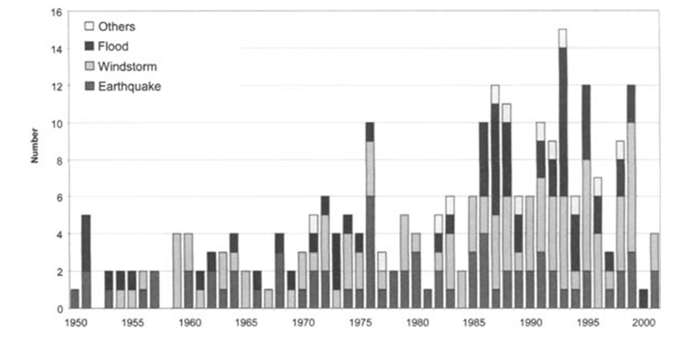
Great natural catastrophes 1950 – 2001
The figure below shows that there is currently no major change in the frequency and intensity of reported earthquakes. Nevertheless, the economic losses caused by earthquakes are increasing.
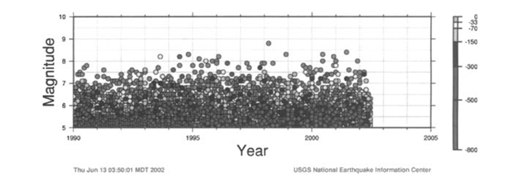
Earthquakes Located by the NEIC, Magnitude 5 and greater
Volcanic Hazards
About 50 to 60 volcanoes erupt every year worldwide. Large eruptions endanger lives, human settlements and livelihoods of the almost 500 million people estimated to live near active volcanoes in 2000. That number will increase in the future as today more than 60 large cities are located near potentially active volcanoes, threatened by volcanic eruption.
Volcanoes with high activity are located predominantly in developing countries, particularly in Latin America, the Caribbean, parts of Asia and in the southwest Pacific. In these countries, despite the improvements in many national civil defense agencies’ capacities to manage volcanic emergencies, eruptions are becoming increasingly risky because of rising population density and intense interweaving of infrastructure in the areas surrounding volcanoes.
As the physical characteristics and chemical properties of a specific volcano become better known, it can be more easily monitored. However, the prediction of an impending eruption can still remain a major challenge for volcanologists. Therefore, predicting future volcanic eruptions and related hazards must also be matched with a series of other forms of mitigation, including the following:
- Volcanic risk analysis.
- Early warning and short-term forecast of eruptions.
- Timely and effectively organized evacuation of people from hazardous areas.
- Development and application of land-use and contingency plans to minimize future volcanic disasters.
- Sustained information and educational programs for the population.
Major volcanic eruptions do not occur spontaneously and are preceded by a variety of physical, geological and chemical changes, which accompany the rise of magma toward the surface. The monitoring and measurement of these changes with well established scientific techniques provide the best opportunity to develop a warning system. Recent volcanic disasters show that the cost of monitoring volcanic activity and pre-disaster planning is very small when compared to the potential losses.
For early warning to be effective, sustained public education and information is necessary. This includes understanding results of volcanological studies and analysis, the possible dangers and the local plans to address them prior to the occurrence of emergency conditions. It can be done through the use of brochures, lectures, or courses although the best prepared communities also conduct regular disaster warning and prevention exercises.
In 1990, the International Association of Volcanology and Chemistry of the Earth’s Interior (IAVCEI) launched a program to support the IDNDR and to promote the reduction of risks related to volcanoes. The initiative selected 16 volcanoes for monitoring and research with the aim of directing attention to a small number of active volcanoes, and to encourage the establishment of a range of research and public-awareness activities aimed at enhancing an understanding of the volcanoes and the hazards they pose.
That commitment demonstrated a concentrated effort within the scientific community to publicize the realistic aspects of disaster reduction by working in close association with communities at risk from volcanic hazards. Such collaborative scientific activities continue to show benefits as quite a lot of work continues with those same volcanoes. As a result of improvements in monitoring made during the IDNDR, better data has been developed, especially as those volcanoes continue to be restless. Ongoing work that would not have occurred were it not for this earlier concentrated attention includes, ongoing German-Indonesian cooperation at Merapi Volcano, on the Indonesian island of Java.
Climate related hazards
Societies are increasingly dependant on medium to long term variations in the climate, such as El Niño/La Niña (see box “El Niño outlooks”), which affect precipitation and temperatures over time-scales of two to three years. These regional climatic shifts, the specific character of which is still very much unknown, develop their own variation in hazard trends, in particular hydro-climatic hazards associated with climate variability. The prevalence of droughts and floods as leading hazards shows that many countries are particularly vulnerable in dealing with current natural variability and extremes, let alone climate change.
The projected changes in climate will adversely affect many regions, in particular tropical and sub-tropical regions of the planet. When dealing with the complex issue of climate change there are some observations that can now be accepted as fact. It is now established that temperatures are increasing globally, although these increases are not evenly distributed around the planet. As the atmosphere becomes warmer throughout the world it can absorb more water vapour, leading to a general increase in humidity. As a result there is the probability that tropical storms and cyclones will be accompanied by extreme precipitation increases.
Unfortunately, these factors have a compound effect on the occurrence and impact of disasters. On the one hand, they affect the intensity and frequency of extreme hydrometeorological events, and on the other hand, they increase the vulnerability of societies. As we know, change in precipitation patterns, soil moisture and vegetation cover, are linked to the occurrence of floods, droughts, but also landslides and debris flow events. Climate change is also resulting in slight sea level rise and may cause more devastating storms and hurricanes in coastal areas. The only natural hazards that are not directly influenced by climate change are, possibly, volcanic eruptions and earthquakes.
The Inter-Agency Task Force on Disaster Reduction (IATF/DR) of the ISDR has a working group dealing with climate and disasters (WG1) and another with wildland fires (WG4). In the area of drought preparedness and mitigation, there are a number of coordinated and collaborative initiatives that are foreseen to be undertaken within the framework of the ISDR Task Force involving all its working groups.
Drought distinction
Absence of a precise and universally accepted definition of drought adds to the confusion as to whether it exists, and if it does the degree of its severity. Thus, drought is often forgotten once it ends, and everybody seems to be caught unawares again by the next one. Most of the drought definitions have therefore been application (impact) specific. Other drought definitions have been regional specific. The discussions of drought here are focused on three types of drought – meteorological, agricultural, and hydrological. Meteorological drought is principally defined by the deficiency of precipitation from expected or normal levels over an extended period of time. Hydrological drought is best defined by deficiencies in surface and subsurface water supplies, leading to a lack of water for meeting normal and specific water demands. Agricultural drought may be characterized by deficiency in the water availability for specific agricultural operations such as deficiency of in soil moisture, which is one of the most critical factors in defining crop production potential.
During the coming decade and century, it is expected that drought vulnerability will increase, mainly due to development pressures, population increases, and environmental degradation that could itself lead to climate change. Several efforts have therefore been made at international, regional and national levels to address drought challenges. The international and regional efforts include the programmes and activities of the organizations and the Drought Monitoring Centres in Africa, of Columbia University and USGS that have established programmes to deal with drought monitoring, prediction, early warning and disaster preparedness. They are also covered by the work of the UN sustainable development conventions.
Drought, unlike sudden-onset disasters, has some unique characteristics that may require different approaches to effectively address how to reduce their impacts:
- Drought does not directly destroy food in storage, shelter or infrastructure.
- Its effects are cumulative.
- It is often very difficult to detect its onset until some major impacts such as lack of water or food become discernible.
- Impacts can be spread over a larger geographical area than the damages that result from most of the other natural disasters, and hence quantification of impacts and provision of disaster relief is far more difficult.
“Amartya Sen, the Nobel prize winning economist of Cambridge University, famously pointed out that ‘in the terrible history of famines in the world, no substantial famine has ever occurred in an independent and democratic country with a relatively free press’. The Human Rights Watch took this to heart, and asserts that ‘the best way to prevent famine today is to secure the right to free expression – so that misguided government policies can be brought to public attention and corrected before food shortages become acute’“
Source: The Economist, 18 August 2001
Further, there are several social and economic parameters that affect the severity of drought including food prices, wars, various intervention methods, human activity, vegetation, water supplies and demands, making it extremely difficult to quantify its severity and also provide universal definition and indicators of drought. Drought risk is a product of a region’s exposure to the natural hazards and its vulnerability to extended periods of water shortage. To reduce serious consequences, affected nations must improve understandings of hazards and the factors that influence vulnerability, and establish comprehensive and integrated early warning systems.
Case: Zimbabwe
Drought is the most common hazard in Zimbabwe, a country whose economy is dependent on agriculture. The incidence of drought is often linked to the occurrence of El Niño episodes and has worsened since the 1980s. Floods frequently occurring in the southern and northern provinces of the country compound drought conditions in other parts of the country. In 1996, there were localized floods resulting from abnormally heavy downpours. However, in 2000, flooding associated with Cyclone Eline caused considerable infrastructure and environmental damage in the country. The livelihoods of more than 250,000 people were affected in rural areas, with 100 fatalities and more than US$ 7.5 million in losses recorded.
Drought has been a recurrent feature in most parts of Southern Africa, with five major periods of drought since 1980: 1982-83, 1987-88, 1991- 92, 1994-95 and 1997-98. Three of these events were regional in scale, with the 1991-92 drought considered the “worst in living memory”, placing more than 20 million people at serious risk.
Case: Central Asia
The persistent multi year drought in Central and Southwest Asia is an example of climatic variability that has affected up to 60 million people in parts of Iran, Afghanistan, Tajikistan, Uzbekistan and Turkmenistan, since November 2001. Chronic political instability in many parts of the region and the recent military action in Afghanistan have further complicated the situation. A recent study by the International Research Institute for Climate Prediction (IRI) concludes that Central and Southwest Asia represent the largest region of persistent drought over the last three years in the world. In Iran alone, 37 million people are affected. Water reserves in the country were down by 45 per cent in 2001, 800,000 heads of livestock were lost in 2000, and 2.6 million hectares of irrigated land and 4 million hectares of rain-fed agriculture were affected. Damage to agriculture and livestock has been estimated by the UN at US$ 2.5 billion in 2001 and US$ 1.7 billions in 2000. Afghanistan and Pakistan are affected on a similar scale.
Climate change, sea level rise and coastal systems
Coastal zones are characterized by much diversity of ecosystems and a variety of socio-economic activities. An estimated 46 million people per year, living in coastal areas, are at risk of flooding from storm surges, and sea-level rise. Climate change will exacerbate these trends with significant impact upon the ecosystems and populations. A growing number of people will, continue to be located in coastal areas. Many traditional communities and subsistence level populations also rely on the resource wealth of coastal areas and continue to be drawn to these higher risk coastal regions.
For example, indigenous coastal and island communities in the Torres Strait of Australia and in New Zealand’s Pacific Island Territories are especially vulnerable. Although adaptation options do exist, such measures are not easily implemented on low-lying land. Also, climate change and sea-level rise issues are not as yet well incorporated into current models and frameworks for coastal zone management.
There is a direct link between tropical sea temperature in the oceans and the frequency of tropical cyclones, hurricanes or typhoons. More heat in the atmosphere means more evaporation which means more rainfall and more flooding in some places, more frequent drought in others, more violent windstorms or heavier snows elsewhere.